Araal geodata
Araal (Western Visayas) is a populated place; located in Philippines in Asia/Manila (GMT+8) time zone. With population of 2,630 people, there are 3064 cities with bigger population in this country. Compared to other cities in Philippines, 64% of cities are located further ↑North; 54% of cities are located further ←West and 94.3% of cities have lower elevation than Araal. Note1
Administrative division(s):
- Level 1: Western Visayas
- Level 2: Province of Negros Occidental
- Level 3: La Carlota City


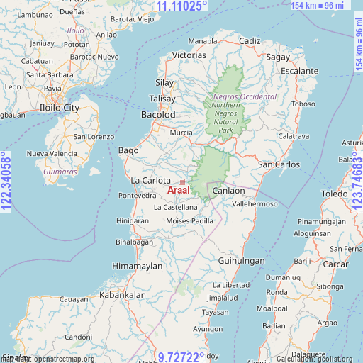
Araal GPS coordinates[2]
10° 25' 10.2" North, 123° 2' 37.32" East
| Map corner | latitude | longitude |
|---|---|---|
| Upper-left | 11.11025°, | 122.34058° |
| Center: | 10.4195°, | 123.0437° |
| Lower-right: | 9.72722°, | 123.74683° |
| Map W x H: | 153.8×153.8 km | = 95.6×95.6mi |
| max Lat: | 20.78733° ⇑64% North |
| Araal: | 10.4195° |
| min Lat: | ⇓36% South 4.65442° |
| min Long | Araal | max Long |
| 117.04868° | 123.0437° | 126.58417° |
| W 54%⇐ | ⇒46% E |
Elevation
Elevation of Araal is 385 m = 1263 ft, and this is 297.1 m = 975 ft above average elevation for this country.
| Max E: |
2262 m = 7421 ft | 5.7% |
| Araal | 385 m 1263 ft | |
| Avg. | 87.9 m = 288 ft | |
Min E: |
-2 m = -7 ft | 94.3% |
See also: Philippines elevation on elevation.city.
Geographical zone
Araal is located in North Torrid zone (between Equator and Tropic of Cancer). Distance of Equator is 1158.5 km =719.9 mi to South.| Distance of | km | miles | from Araal |
|---|---|---|---|
| North Pole | 8848.5 | 5498.2 | to North |
| Arctic Circle | 6242.6 | 3879 | to North |
| Tropic Cancer | 1447.4 | 899.4 | to North |
| Equator | 1158.5 | 719.9 | to South |


Nearby cities:
15 places around Araal: (largest is in red/bold)
• Antipolo
11.1 km =6.9 mi,  231°
231°
• Atipuluhan
13.7 km =8.5 mi,  319°
319°
• Cabacungan
14.5 km =9 mi,  137°
137°
• Camandag
9.9 km =6.2 mi,  165°
165°
• Carmen Grande
14.7 km =9.1 mi,  252°
252°
• Haguimit
3.6 km =2.2 mi, 232°
• La Carlota
13.4 km =8.3 mi,  272°
272°
• La Castellana
10.9 km =6.8 mi,  192°
192°
• La Granja
6 km =3.7 mi,  257°
257°
• Maao
9.7 km =6 mi, 323°
• Minuyan
12.4 km =7.7 mi,  32°
32°
• Sagang
7.2 km =4.5 mi,  154°
154°
• San Miguel
2.5 km =1.6 mi, 259°
• San Miguel
13.9 km =8.6 mi,  17°
17°
• Yubo
4.3 km =2.7 mi, 140°
Sources, notices
• [Note1] Compared only with cities in Philippines existing in our database
• [Src1] Map data: © OpenStreetMap contributors (CC-BY-SA)
• [Src2] Other city data from geonames.org with taken over terms of usage.
• [Src3] Geographical zone / Annual Mean Temperature by Robert A. Rohde @ Wikipedia
