La Granja geodata
La Granja (Western Visayas) is a populated place; located in Philippines in Asia/Manila (GMT+8) time zone. With population of 5,277 people, there are 1208 cities with bigger population in this country. Compared to other cities in Philippines, 64.1% of cities are located further ↑North; 53% of cities are located further ←West and 83.1% of cities have lower elevation than La Granja. Note1
Administrative division(s):
- Level 1: Western Visayas
- Level 2: Province of Negros Occidental
- Level 3: La Carlota City


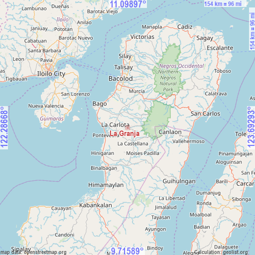
La Granja GPS coordinates[2]
10° 24' 29.52" North, 122° 59' 23.28" East
| Map corner | latitude | longitude |
|---|---|---|
| Upper-left | 11.09897°, | 122.28668° |
| Center: | 10.4082°, | 122.9898° |
| Lower-right: | 9.71589°, | 123.69293° |
| Map W x H: | 153.8×153.8 km | = 95.6×95.6mi |
| max Lat: | 20.78733° ⇑64.1% North |
| La Granja: | 10.4082° |
| min Lat: | ⇓35.9% South 4.65442° |
| min Long | La Granja | max Long |
| 117.04868° | 122.9898° | 126.58417° |
| W 53%⇐ | ⇒47% E |
Elevation
Elevation of La Granja is 117 m = 384 ft, and this is 29.1 m = 95 ft above average elevation for this country.
| Max E: |
2262 m = 7421 ft | 16.9% |
| La Granja | 117 m 384 ft | |
| Avg. | 87.9 m = 288 ft | |
Min E: |
-2 m = -7 ft | 83.1% |
See also: Philippines elevation on elevation.city.
Geographical zone
La Granja is located in North Torrid zone (between Equator and Tropic of Cancer). Distance of Equator is 1157.3 km =719.1 mi to South.| Distance of | km | miles | from La Granja |
|---|---|---|---|
| North Pole | 8849.8 | 5499 | to North |
| Arctic Circle | 6243.9 | 3879.8 | to North |
| Tropic Cancer | 1448.6 | 900.1 | to North |
| Equator | 1157.3 | 719.1 | to South |


Nearby cities:
15 places around La Granja: (largest is in red/bold)
• Antipolo
6.4 km =4 mi,  205°
205°
• Araal
6 km =3.7 mi,  77°
77°
• Atipuluhan
12.1 km =7.5 mi,  345°
345°
• Baliwagan
10.9 km =6.8 mi,  263°
263°
• Camandag
11.8 km =7.3 mi,  134°
134°
• Carmen Grande
8.8 km =5.5 mi,  247°
247°
• Haguimit
3.2 km =2 mi,  106°
106°
• La Carlota
7.7 km =4.8 mi,  283°
283°
• La Castellana
10 km =6.2 mi,  159°
159°
• Maao
9.1 km =5.7 mi,  0°
0°
• Sagang
10.4 km =6.5 mi,  120°
120°
• Sagasa
12.4 km =7.7 mi,  302°
302°
• San Miguel
3.5 km =2.2 mi, 76°
• Sibucao
11.3 km =7 mi, 275°
• Yubo
8.9 km =5.5 mi,  103°
103°
Sources, notices
• [Note1] Compared only with cities in Philippines existing in our database
• [Src1] Map data: © OpenStreetMap contributors (CC-BY-SA)
• [Src2] Other city data from geonames.org with taken over terms of usage.
• [Src3] Geographical zone / Annual Mean Temperature by Robert A. Rohde @ Wikipedia
