Ani-e geodata
Ani-e (Northern Mindanao) is a populated place; located in Philippines in Asia/Manila (GMT+8) time zone. With population of 3,324 people, there are 2201 cities with bigger population in this country. Compared to other cities in Philippines, 77.5% of cities are located further ↑North; 85.7% of cities are located further ←West and 96.4% of cities have lower elevation than Ani-e. Note1
Administrative division(s):
- Level 1: Northern Mindanao
- Level 2: Province of Misamis Oriental
- Level 3: Claveria


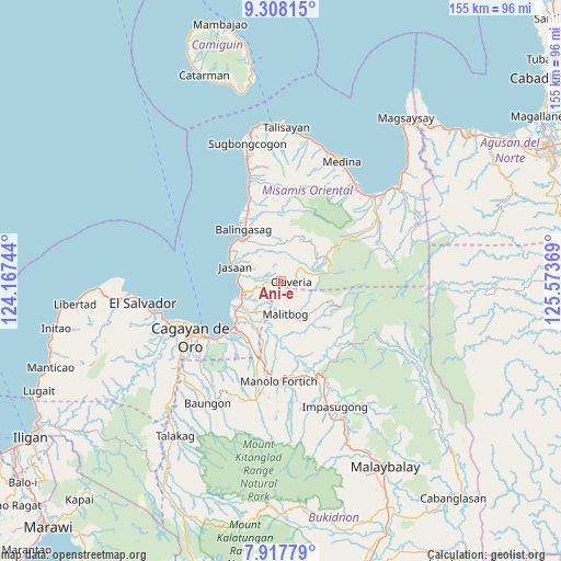
Ani-e GPS coordinates[2]
8° 36' 48.996" North, 124° 52' 14.016" East
| Map corner | latitude | longitude |
|---|---|---|
| Upper-left | 9.30815°, | 124.16744° |
| Center: | 8.61361°, | 124.87056° |
| Lower-right: | 7.91779°, | 125.57369° |
| Map W x H: | 154.6×154.6 km | = 96.1×96.1mi |
| max Lat: | 20.78733° ⇑77.5% North |
| Ani-e: | 8.61361° |
| min Lat: | ⇓22.5% South 4.65442° |
| min Long | Ani-e | max Long |
| 117.04868° | 124.87056° | 126.58417° |
| W 85.7%⇐ | ⇒14.3% E |
Elevation
Elevation of Ani-e is 536 m = 1759 ft, and this is 448.1 m = 1470 ft above average elevation for this country.
| Max E: |
2262 m = 7421 ft | 3.6% |
| Ani-e | 536 m 1759 ft | |
| Avg. | 87.9 m = 288 ft | |
Min E: |
-2 m = -7 ft | 96.4% |
See also: Philippines elevation on elevation.city.
Geographical zone
Ani-e is located in North Torrid zone (between Equator and Tropic of Cancer). Distance of Equator is 957.7 km =595.1 mi to South.| Distance of | km | miles | from Ani-e |
|---|---|---|---|
| North Pole | 9049.3 | 5623 | to North |
| Arctic Circle | 6443.4 | 4003.7 | to North |
| Tropic Cancer | 1648.2 | 1024.1 | to North |
| Equator | 957.7 | 595.1 | to South |


Nearby cities:
15 places around Ani-e: (largest is in red/bold)
• Aplaya
11.3 km =7 mi,  267°
267°
• Baliwagan
14.6 km =9.1 mi,  323°
323°
• Binitinan
15 km =9.3 mi, 315°
• Bugo
16.9 km =10.5 mi,  226°
226°
• Claveria
2.7 km =1.7 mi,  98°
98°
• Hinapalanan
3 km =1.9 mi,  5°
5°
• Jasaan
13.4 km =8.3 mi,  289°
289°
• Kimaya
6.4 km =4 mi,  211°
211°
• Malitbog
9 km =5.6 mi,  171°
171°
• Patrocinio
2.8 km =1.7 mi, 267°
• San Martin
12.4 km =7.7 mi,  241°
241°
• Santa Ana
14.4 km =8.9 mi,  221°
221°
• Solana
11 km =6.8 mi,  275°
275°
• Tagoloan
15.2 km =9.4 mi, 237°
• Villanueva
10.8 km =6.7 mi,  255°
255°
Sources, notices
• [Note1] Compared only with cities in Philippines existing in our database
• [Src1] Map data: © OpenStreetMap contributors (CC-BY-SA)
• [Src2] Other city data from geonames.org with taken over terms of usage.
• [Src3] Geographical zone / Annual Mean Temperature by Robert A. Rohde @ Wikipedia
