San Martin geodata
San Martin (Northern Mindanao) is a populated place; located in Philippines in Asia/Manila (GMT+8) time zone. With population of 3,434 people, there are 2112 cities with bigger population in this country. Compared to other cities in Philippines, 78% of cities are located further ↑North; 83.5% of cities are located further ←West and 67.4% of cities have higher elevation than San Martin. Note1
Administrative division(s):
- Level 1: Northern Mindanao
- Level 2: Province of Misamis Oriental
- Level 3: Villanueva


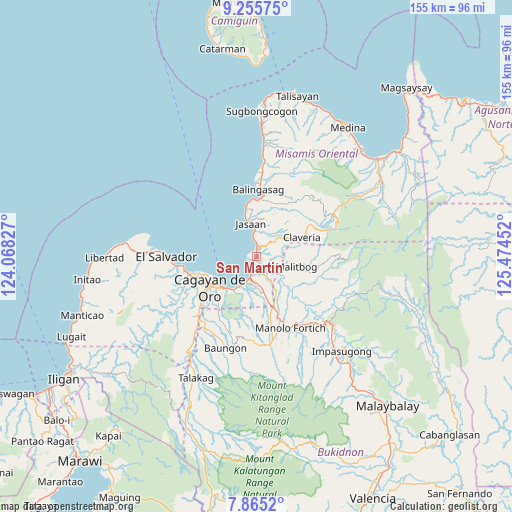
San Martin GPS coordinates[2]
8° 33' 39.996" North, 124° 46' 17.004" East
| Map corner | latitude | longitude |
|---|---|---|
| Upper-left | 9.25575°, | 124.06827° |
| Center: | 8.56111°, | 124.77139° |
| Lower-right: | 7.8652°, | 125.47452° |
| Map W x H: | 154.6×154.6 km | = 96.1×96.1mi |
| max Lat: | 20.78733° ⇑78% North |
| San Martin: | 8.56111° |
| min Lat: | ⇓22% South 4.65442° |
| min Long | San Martin | max Long |
| 117.04868° | 124.77139° | 126.58417° |
| W 83.5%⇐ | ⇒16.5% E |
Elevation
Elevation of San Martin is 13 m = 43 ft, and this is 74.9 m = 246 ft below average elevation for this country.
| Max E: |
2262 m = 7421 ft | 67.4% |
| Avg. | 87.9 m = 288 ft | |
| San Martin | 13 m = 43 ft | |
Min E: |
-2 m = -7 ft | 32.6% |
See also: Philippines elevation on elevation.city.
Geographical zone
San Martin is located in North Torrid zone (between Equator and Tropic of Cancer). Distance of Equator is 951.9 km =591.5 mi to South.| Distance of | km | miles | from San Martin |
|---|---|---|---|
| North Pole | 9055.2 | 5626.6 | to North |
| Arctic Circle | 6449.3 | 4007.4 | to North |
| Tropic Cancer | 1654 | 1027.7 | to North |
| Equator | 951.9 | 591.5 | to South |


Nearby cities:
15 places around San Martin: (largest is in red/bold)
• Agusan
8.7 km =5.4 mi,  205°
205°
• Ani-e
12.4 km =7.7 mi,  61°
61°
• Aplaya
5.3 km =3.3 mi,  356°
356°
• Bugo
6 km =3.7 mi,  192°
192°
• Claveria
14.6 km =9.1 mi,  68°
68°
• Hinapalanan
14.2 km =8.8 mi,  51°
51°
• Jasaan
10.5 km =6.5 mi,  350°
350°
• Kimaya
7.5 km =4.7 mi,  86°
86°
• Malitbog
12.6 km =7.8 mi,  103°
103°
• Mambatangan
15.8 km =9.8 mi,  154°
154°
• Patrocinio
10 km =6.2 mi, 54°
• Santa Ana
5.1 km =3.2 mi,  165°
165°
• Solana
6.9 km =4.3 mi, 359°
• Tagoloan
3.1 km =1.9 mi,  218°
218°
• Villanueva
3.1 km =1.9 mi,  8°
8°
Sources, notices
• [Note1] Compared only with cities in Philippines existing in our database
• [Src1] Map data: © OpenStreetMap contributors (CC-BY-SA)
• [Src2] Other city data from geonames.org with taken over terms of usage.
• [Src3] Geographical zone / Annual Mean Temperature by Robert A. Rohde @ Wikipedia
