Amdos geodata
Amdos (Central Visayas) is a populated place; located in Philippines in Asia/Manila (GMT+8) time zone. With population of 2,247 people, there are 3790 cities with bigger population in this country. Compared to other cities in Philippines, 69.6% of cities are located further ↑North; 55% of cities are located further ←West and 95.7% of cities have lower elevation than Amdos. Note1
Administrative division(s):
- Level 1: Central Visayas
- Level 2: Province of Negros Oriental
- Level 3: Ayungon


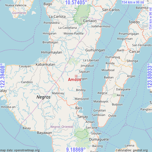
Amdos GPS coordinates[2]
9° 52' 55.56" North, 123° 5' 49.92" East
| Map corner | latitude | longitude |
|---|---|---|
| Upper-left | 10.57405°, | 122.39408° |
| Center: | 9.8821°, | 123.0972° |
| Lower-right: | 9.18869°, | 123.80033° |
| Map W x H: | 154×154 km | = 95.7×95.7mi |
| max Lat: | 20.78733° ⇑69.6% North |
| Amdos: | 9.8821° |
| min Lat: | ⇓30.4% South 4.65442° |
| min Long | Amdos | max Long |
| 117.04868° | 123.0972° | 126.58417° |
| W 55%⇐ | ⇒45% E |
Elevation
Elevation of Amdos is 478 m = 1568 ft, and this is 390.1 m = 1280 ft above average elevation for this country.
| Max E: |
2262 m = 7421 ft | 4.3% |
| Amdos | 478 m 1568 ft | |
| Avg. | 87.9 m = 288 ft | |
Min E: |
-2 m = -7 ft | 95.7% |
See also: Philippines elevation on elevation.city.
Geographical zone
Amdos is located in North Torrid zone (between Equator and Tropic of Cancer). Distance of Equator is 1098.8 km =682.8 mi to South.| Distance of | km | miles | from Amdos |
|---|---|---|---|
| North Pole | 8908.3 | 5535.4 | to North |
| Arctic Circle | 6302.4 | 3916.1 | to North |
| Tropic Cancer | 1507.1 | 936.5 | to North |
| Equator | 1098.8 | 682.8 | to South |


Nearby cities:
15 places around Amdos: (largest is in red/bold)
• Ayungon
5.8 km =3.6 mi,  116°
116°
• Bagtic
23.7 km =14.7 mi,  203°
203°
• Bolisong
22.1 km =13.7 mi,  164°
164°
• Bulod
22.8 km =14.2 mi,  165°
165°
• Jimalalud
15.6 km =9.7 mi,  46°
46°
• Kandabong
22 km =13.7 mi,  186°
186°
• La Libertad
21.9 km =13.6 mi,  42°
42°
• Nalundan
15.1 km =9.4 mi, 192°
• Payabon
14.5 km =9 mi, 160°
• Tambalan
3.1 km =1.9 mi,  344°
344°
• Tambo
4.8 km =3 mi,  287°
287°
• Tampocon
5.3 km =3.3 mi,  132°
132°
• Tayasan
9.2 km =5.7 mi,  59°
59°
• Tiguib
10 km =6.2 mi, 155°
• Tinaogan
12.8 km =8 mi,  153°
153°
Sources, notices
• [Note1] Compared only with cities in Philippines existing in our database
• [Src1] Map data: © OpenStreetMap contributors (CC-BY-SA)
• [Src2] Other city data from geonames.org with taken over terms of usage.
• [Src3] Geographical zone / Annual Mean Temperature by Robert A. Rohde @ Wikipedia
