Tambo geodata
Tambo (Central Visayas) is a populated place; located in Philippines in Asia/Manila (GMT+8) time zone. With population of 3,196 people, there are 2308 cities with bigger population in this country. Compared to other cities in Philippines, 69.4% of cities are located further ↑North; 54.3% of cities are located further ←West and 95.2% of cities have lower elevation than Tambo. Note1
Administrative division(s):
- Level 1: Central Visayas
- Level 2: Province of Negros Oriental
- Level 3: Ayungon


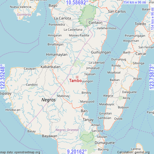
Tambo GPS coordinates[2]
9° 53' 42" North, 123° 3' 20.16" East
| Map corner | latitude | longitude |
|---|---|---|
| Upper-left | 10.58692°, | 122.35248° |
| Center: | 9.895°, | 123.0556° |
| Lower-right: | 9.20162°, | 123.75873° |
| Map W x H: | 154×154 km | = 95.7×95.7mi |
| max Lat: | 20.78733° ⇑69.4% North |
| Tambo: | 9.895° |
| min Lat: | ⇓30.6% South 4.65442° |
| min Long | Tambo | max Long |
| 117.04868° | 123.0556° | 126.58417° |
| W 54.3%⇐ | ⇒45.7% E |
Elevation
Elevation of Tambo is 433 m = 1421 ft, and this is 345.1 m = 1132 ft above average elevation for this country.
| Max E: |
2262 m = 7421 ft | 4.8% |
| Tambo | 433 m 1421 ft | |
| Avg. | 87.9 m = 288 ft | |
Min E: |
-2 m = -7 ft | 95.2% |
See also: Philippines elevation on elevation.city.
Geographical zone
Tambo is located in North Torrid zone (between Equator and Tropic of Cancer). Distance of Equator is 1100.2 km =683.6 mi to South.| Distance of | km | miles | from Tambo |
|---|---|---|---|
| North Pole | 8906.8 | 5534.4 | to North |
| Arctic Circle | 6301 | 3915.3 | to North |
| Tropic Cancer | 1505.7 | 935.6 | to North |
| Equator | 1100.2 | 683.6 | to South |


Nearby cities:
15 places around Tambo: (largest is in red/bold)
• Abis
23.2 km =14.4 mi,  211°
211°
• Amdos
4.8 km =3 mi,  107°
107°
• Ayungon
10.5 km =6.5 mi, 112°
• Bagtic
23.7 km =14.7 mi,  191°
191°
• Cabanbanan
23.7 km =14.7 mi,  333°
333°
• Camingawan
21.2 km =13.2 mi,  270°
270°
• Jimalalud
18.4 km =11.4 mi,  59°
59°
• Kandabong
23.3 km =14.5 mi,  175°
175°
• Nalundan
16.2 km =10.1 mi, 175°
• Payabon
17.8 km =11.1 mi,  148°
148°
• Tambalan
4 km =2.5 mi,  68°
68°
• Tampocon
9.9 km =6.2 mi,  120°
120°
• Tayasan
12.9 km =8 mi,  75°
75°
• Tiguib
13.6 km =8.5 mi,  140°
140°
• Tinaogan
16.5 km =10.3 mi, 141°
Sources, notices
• [Note1] Compared only with cities in Philippines existing in our database
• [Src1] Map data: © OpenStreetMap contributors (CC-BY-SA)
• [Src2] Other city data from geonames.org with taken over terms of usage.
• [Src3] Geographical zone / Annual Mean Temperature by Robert A. Rohde @ Wikipedia
