Laparay geodata
Laparay (Zamboanga Peninsula) is a populated place; located in Philippines in Asia/Manila (GMT+8) time zone. With population of 2,140 people, there are 4009 cities with bigger population in this country. Compared to other cities in Philippines, 87.8% of cities are located further ↑North; 50.1% of cities are located further ←West and 73.2% of cities have higher elevation than Laparay. Note1
Administrative division(s):
- Level 1: Zamboanga Peninsula
- Level 2: Province of Zamboanga Sibugay
- Level 3: Talusan


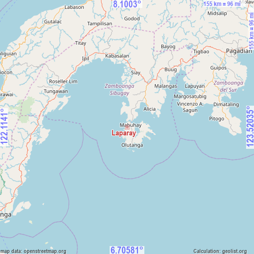
Laparay GPS coordinates[2]
7° 24' 12.996" North, 122° 49' 1.992" East
| Map corner | latitude | longitude |
|---|---|---|
| Upper-left | 8.1003°, | 122.1141° |
| Center: | 7.40361°, | 122.81722° |
| Lower-right: | 6.70581°, | 123.52035° |
| Map W x H: | 155.1×155.1 km | = 96.4×96.4mi |
| max Lat: | 20.78733° ⇑87.8% North |
| Laparay: | 7.40361° |
| min Lat: | ⇓12.2% South 4.65442° |
| min Long | Laparay | max Long |
| 117.04868° | 122.81722° | 126.58417° |
| W 50.1%⇐ | ⇒49.9% E |
Elevation
Elevation of Laparay is 11 m = 36 ft, and this is 76.9 m = 252 ft below average elevation for this country.
| Max E: |
2262 m = 7421 ft | 73.2% |
| Avg. | 87.9 m = 288 ft | |
| Laparay | 11 m = 36 ft | |
Min E: |
-2 m = -7 ft | 26.8% |
See also: Philippines elevation on elevation.city.
Geographical zone
Laparay is located in North Torrid zone (between Equator and Tropic of Cancer). Distance of Equator is 823.2 km =511.5 mi to South.| Distance of | km | miles | from Laparay |
|---|---|---|---|
| North Pole | 9183.9 | 5706.6 | to North |
| Arctic Circle | 6578 | 4087.4 | to North |
| Tropic Cancer | 1782.7 | 1107.7 | to North |
| Equator | 823.2 | 511.5 | to South |


Nearby cities:
15 places around Laparay: (largest is in red/bold)
• Alicia
17.5 km =10.9 mi,  45°
45°
• Batu
38.9 km =24.2 mi,  1°
1°
• Dawa-Dawa
7.5 km =4.7 mi,  16°
16°
• Ganyangan
32.3 km =20.1 mi, 18°
• Imelda
31 km =19.3 mi,  29°
29°
• Katipunan
19.9 km =12.4 mi, 4°
• Kawayan
16.2 km =10.1 mi, 22°
• La Dicha
36.5 km =22.7 mi, 33°
• Mabuhay
2.7 km =1.7 mi, 53°
• Malangas
34.6 km =21.5 mi,  43°
43°
• Monching
35.1 km =21.8 mi,  8°
8°
• Olutanga
10.8 km =6.7 mi,  162°
162°
• Payao
20.4 km =12.7 mi,  355°
355°
• Siay
32.9 km =20.4 mi, 8°
• Talusan
2.7 km =1.7 mi,  343°
343°
Sources, notices
• [Note1] Compared only with cities in Philippines existing in our database
• [Src1] Map data: © OpenStreetMap contributors (CC-BY-SA)
• [Src2] Other city data from geonames.org with taken over terms of usage.
• [Src3] Geographical zone / Annual Mean Temperature by Robert A. Rohde @ Wikipedia
