Siay geodata
Siay (Zamboanga Peninsula) is a populated place; located in Philippines in Asia/Manila (GMT+8) time zone. With population of 2,351 people, there are 3557 cities with bigger population in this country. Compared to other cities in Philippines, 85.2% of cities are located further ↑North; 50.9% of cities are located further ←West and 92.7% of cities have higher elevation than Siay. Note1
Administrative division(s):
- Level 1: Zamboanga Peninsula
- Level 2: Province of Zamboanga Sibugay
- Level 3: Siay


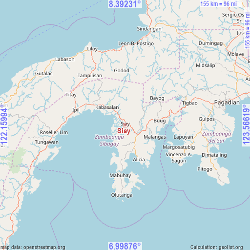
Siay GPS coordinates[2]
7° 41' 45.996" North, 122° 51' 47.016" East
| Map corner | latitude | longitude |
|---|---|---|
| Upper-left | 8.39231°, | 122.15994° |
| Center: | 7.69611°, | 122.86306° |
| Lower-right: | 6.99876°, | 123.56619° |
| Map W x H: | 154.9×155 km | = 96.3×96.3mi |
| max Lat: | 20.78733° ⇑85.2% North |
| Siay: | 7.69611° |
| min Lat: | ⇓14.8% South 4.65442° |
| min Long | Siay | max Long |
| 117.04868° | 122.86306° | 126.58417° |
| W 50.9%⇐ | ⇒49.1% E |
Elevation
Elevation of Siay is 6 m = 20 ft, and this is 81.9 m = 269 ft below average elevation for this country.
| Max E: |
2262 m = 7421 ft | 92.7% |
| Avg. | 87.9 m = 288 ft | |
| Siay | 6 m = 20 ft | |
Min E: |
-2 m = -7 ft | 7.3% |
See also: Philippines elevation on elevation.city.
Geographical zone
Siay is located in North Torrid zone (between Equator and Tropic of Cancer). Distance of Equator is 855.7 km =531.7 mi to South.| Distance of | km | miles | from Siay |
|---|---|---|---|
| North Pole | 9151.3 | 5686.4 | to North |
| Arctic Circle | 6545.4 | 4067.1 | to North |
| Tropic Cancer | 1750.2 | 1087.5 | to North |
| Equator | 855.7 | 531.7 | to South |


Nearby cities:
15 places around Siay: (largest is in red/bold)
• Alicia
21.6 km =13.4 mi,  159°
159°
• Batu
7.4 km =4.6 mi,  329°
329°
• Buug
22 km =13.7 mi,  80°
80°
• Del Monte
16.3 km =10.1 mi, 78°
• Diplahan
17.1 km =10.6 mi, 82°
• Ganyangan
5.5 km =3.4 mi,  110°
110°
• Imelda
11.4 km =7.1 mi,  118°
118°
• Kabasalan
15.6 km =9.7 mi,  316°
316°
• Katipunan
13.1 km =8.1 mi,  195°
195°
• Kawayan
17.6 km =10.9 mi,  176°
176°
• La Dicha
15.5 km =9.6 mi,  98°
98°
• Malangas
20 km =12.4 mi, 111°
• Monching
2.2 km =1.4 mi,  9°
9°
• Naga
14.9 km =9.3 mi,  303°
303°
• Payao
13.9 km =8.6 mi,  208°
208°
Sources, notices
• [Note1] Compared only with cities in Philippines existing in our database
• [Src1] Map data: © OpenStreetMap contributors (CC-BY-SA)
• [Src2] Other city data from geonames.org with taken over terms of usage.
• [Src3] Geographical zone / Annual Mean Temperature by Robert A. Rohde @ Wikipedia
