Kajatian geodata
Kajatian (Autonomous Region in Muslim Mindanao) is a populated place; located in Philippines in Asia/Manila (GMT+8) time zone. With population of 5,436 people, there are 1169 cities with bigger population in this country. Compared to other cities in Philippines, 97.7% of cities are located further ↑North; 76.5% of cities are located further →East and 78.5% of cities have lower elevation than Kajatian. Note1
Administrative division(s):
- Level 1: Autonomous Region in Muslim Mindanao
- Level 2: Province of Sulu
- Level 3: Indanan


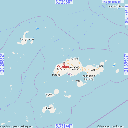
Kajatian GPS coordinates[2]
6° 1' 51.996" North, 120° 59' 30.984" East
| Map corner | latitude | longitude |
|---|---|---|
| Upper-left | 6.72988°, | 120.28882° |
| Center: | 6.03111°, | 120.99194° |
| Lower-right: | 5.33144°, | 121.69507° |
| Map W x H: | 155.5×155.5 km | = 96.6×96.6mi |
| max Lat: | 20.78733° ⇑97.7% North |
| Kajatian: | 6.03111° |
| min Lat: | ⇓2.3% South 4.65442° |
| min Long | Kajatian | max Long |
| 117.04868° | 120.99194° | 126.58417° |
| W 23.5%⇐ | ⇒76.5% E |
Elevation
Elevation of Kajatian is 82 m = 269 ft, and this is 5.9 m = 19 ft below average elevation for this country.
| Max E: |
2262 m = 7421 ft | 21.5% |
| Avg. | 87.9 m = 288 ft | |
| Kajatian | 82 m = 269 ft | |
Min E: |
-2 m = -7 ft | 78.5% |
See also: Philippines elevation on elevation.city.
Geographical zone
Kajatian is located in North Torrid zone (between Equator and Tropic of Cancer). Distance of Equator is 670.6 km =416.7 mi to South.| Distance of | km | miles | from Kajatian |
|---|---|---|---|
| North Pole | 9336.5 | 5801.4 | to North |
| Arctic Circle | 6730.6 | 4182.2 | to North |
| Tropic Cancer | 1935.3 | 1202.5 | to North |
| Equator | 670.6 | 416.7 | to South |


Nearby cities:
15 places around Kajatian: (largest is in red/bold)
• Anuling
1.7 km =1.1 mi,  73°
73°
• Bangkal
9.2 km =5.7 mi,  64°
64°
• Bato Bato
5.1 km =3.2 mi,  274°
274°
• Baunu-Timbangan
2.9 km =1.8 mi,  175°
175°
• Binuang
11.2 km =7 mi,  137°
137°
• Buansa
3.4 km =2.1 mi,  260°
260°
• Jolo
2.6 km =1.6 mi,  25°
25°
• Kagay
9.7 km =6 mi, 255°
• Langpas
7.8 km =4.8 mi,  217°
217°
• Maimbung
11.5 km =7.1 mi,  161°
161°
• Mauboh
12.1 km =7.5 mi,  112°
112°
• Panabuan
8.4 km =5.2 mi,  202°
202°
• Patikul
14.1 km =8.8 mi, 62°
• Payuhan
14.1 km =8.8 mi,  225°
225°
• Sionogan
5.6 km =3.5 mi,  239°
239°
Sources, notices
• [Note1] Compared only with cities in Philippines existing in our database
• [Src1] Map data: © OpenStreetMap contributors (CC-BY-SA)
• [Src2] Other city data from geonames.org with taken over terms of usage.
• [Src3] Geographical zone / Annual Mean Temperature by Robert A. Rohde @ Wikipedia
