Patikul geodata
Patikul (Autonomous Region in Muslim Mindanao) is a seat of a third-order administrative division; located in Philippines in Asia/Manila (GMT+8) time zone. In our database, there are 4166 cities with bigger population. Compared to other cities in Philippines, 97.4% of cities are located further ↑North; 73.7% of cities are located further →East and 92.7% of cities have higher elevation than Patikul. Note1
Administrative division(s):
- Level 1: Autonomous Region in Muslim Mindanao
- Level 2: Province of Sulu
- Level 3: Patikul


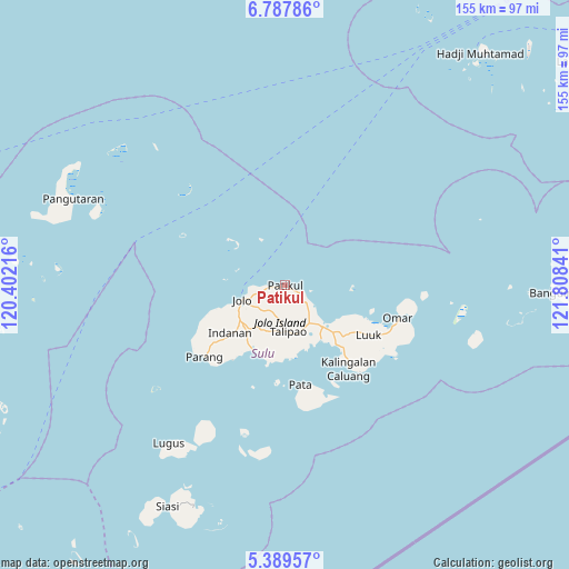
Patikul GPS coordinates[2]
6° 5' 21.012" North, 121° 6' 19.008" East
| Map corner | latitude | longitude |
|---|---|---|
| Upper-left | 6.78786°, | 120.40216° |
| Center: | 6.08917°, | 121.10528° |
| Lower-right: | 5.38957°, | 121.80841° |
| Map W x H: | 155.5×155.5 km | = 96.6×96.6mi |
| max Lat: | 20.78733° ⇑97.4% North |
| Patikul: | 6.08917° |
| min Lat: | ⇓2.6% South 4.65442° |
| min Long | Patikul | max Long |
| 117.04868° | 121.10528° | 126.58417° |
| W 26.3%⇐ | ⇒73.7% E |
Elevation
Elevation of Patikul is 6 m = 20 ft, and this is 81.9 m = 269 ft below average elevation for this country.
| Max E: |
2262 m = 7421 ft | 92.7% |
| Avg. | 87.9 m = 288 ft | |
| Patikul | 6 m = 20 ft | |
Min E: |
-2 m = -7 ft | 7.3% |
See also: Philippines elevation on elevation.city.
Geographical zone
Patikul is located in North Torrid zone (between Equator and Tropic of Cancer). Distance of Equator is 677.1 km =420.7 mi to South.| Distance of | km | miles | from Patikul |
|---|---|---|---|
| North Pole | 9330 | 5797.4 | to North |
| Arctic Circle | 6724.1 | 4178.2 | to North |
| Tropic Cancer | 1928.9 | 1198.6 | to North |
| Equator | 677.1 | 420.7 | to South |


Nearby cities:
15 places around Patikul: (largest is in red/bold)
• Anuling
12.4 km =7.7 mi,  241°
241°
• Bangkal
4.9 km =3 mi, 239°
• Bato Bato
18.6 km =11.6 mi,  250°
250°
• Baunu-Timbangan
15.4 km =9.6 mi,  232°
232°
• Binuang
15.5 km =9.6 mi,  198°
198°
• Buansa
17.4 km =10.8 mi, 246°
• Jolo
12.1 km =7.5 mi, 250°
• Kajatian
14.1 km =8.8 mi, 242°
• Kansipati
17.3 km =10.7 mi,  124°
124°
• Marsada
17.5 km =10.9 mi,  179°
179°
• Mauboh
11.1 km =6.9 mi,  186°
186°
• Pananaw
17.1 km =10.6 mi,  134°
134°
• Pandakan
13 km =8.1 mi,  149°
149°
• Punay
17.5 km =10.9 mi,  144°
144°
• Talipao
12.6 km =7.8 mi,  174°
174°
Sources, notices
• [Note1] Compared only with cities in Philippines existing in our database
• [Src1] Map data: © OpenStreetMap contributors (CC-BY-SA)
• [Src2] Other city data from geonames.org with taken over terms of usage.
• [Src3] Geographical zone / Annual Mean Temperature by Robert A. Rohde @ Wikipedia
