Margos geodata
Margos (Zamboanga Peninsula) is a populated place; located in Philippines in Asia/Manila (GMT+8) time zone. With population of 2,264 people, there are 3759 cities with bigger population in this country. Compared to other cities in Philippines, 83.2% of cities are located further ↑North; 64.9% of cities are located further ←West and 100% of cities have higher elevation than Margos. Note1


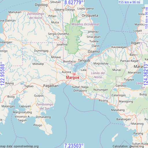
Margos GPS coordinates[2]
7° 55' 55.2" North, 123° 39' 32.4" East
| Map corner | latitude | longitude |
|---|---|---|
| Upper-left | 8.62779°, | 122.95588° |
| Center: | 7.932°, | 123.659° |
| Lower-right: | 7.23503°, | 124.36213° |
| Map W x H: | 154.9×154.9 km | = 96.3×96.3mi |
| max Lat: | 20.78733° ⇑83.2% North |
| Margos: | 7.932° |
| min Lat: | ⇓16.8% South 4.65442° |
| min Long | Margos | max Long |
| 117.04868° | 123.659° | 126.58417° |
| W 64.9%⇐ | ⇒35.1% E |
Elevation
Elevation of Margos is 0 m = 0 ft, and this is 87.9 m = 288 ft below average elevation for this country.
| Max E: |
2262 m = 7421 ft | 100% |
| Avg. | 87.9 m = 288 ft | |
| Margos | 0 m = 0 ft | |
Min E: |
-2 m = -7 ft | 0% |
See also: Philippines elevation on elevation.city.
Geographical zone
Margos is located in North Torrid zone (between Equator and Tropic of Cancer). Distance of Equator is 882 km =548 mi to South.| Distance of | km | miles | from Margos |
|---|---|---|---|
| North Pole | 9125.1 | 5670.1 | to North |
| Arctic Circle | 6519.2 | 4050.8 | to North |
| Tropic Cancer | 1724 | 1071.2 | to North |
| Equator | 882 | 548 | to South |


Nearby cities:
15 places around Margos: (largest is in red/bold)
• Aurora
8.7 km =5.4 mi,  283°
283°
• Balili
9.2 km =5.7 mi,  116°
116°
• Bonifacio
14.3 km =8.9 mi,  339°
339°
• Caromatan
16.3 km =10.1 mi,  158°
158°
• Gubaan
11.5 km =7.1 mi,  294°
294°
• Kapatagan
12.6 km =7.8 mi,  106°
106°
• Lala
10.7 km =6.6 mi,  64°
64°
• Lanipao
13.2 km =8.2 mi,  78°
78°
• Lapining
3.4 km =2.1 mi, 107°
• Maranding
12.4 km =7.7 mi,  93°
93°
• Panalo-on
10.2 km =6.3 mi,  99°
99°
• Pangabuan
14.5 km =9 mi,  16°
16°
• Sumalig
7.4 km =4.6 mi,  3°
3°
• Taguitic
3.2 km =2 mi, 283°
• Tucuran
12.9 km =8 mi,  226°
226°
Sources, notices
• [Note1] Compared only with cities in Philippines existing in our database
• [Src1] Map data: © OpenStreetMap contributors (CC-BY-SA)
• [Src2] Other city data from geonames.org with taken over terms of usage.
• [Src3] Geographical zone / Annual Mean Temperature by Robert A. Rohde @ Wikipedia
