Kapatagan geodata
Kapatagan (Northern Mindanao) is a populated place; located in Philippines in Asia/Manila (GMT+8) time zone. With population of 9,664 people, there are 636 cities with bigger population in this country. Compared to other cities in Philippines, 83.5% of cities are located further ↑North; 67.4% of cities are located further ←West and 57.6% of cities have higher elevation than Kapatagan. Note1
Administrative division(s):
- Level 1: Northern Mindanao
- Level 2: Province of Lanao del Norte
- Level 3: Kapatagan


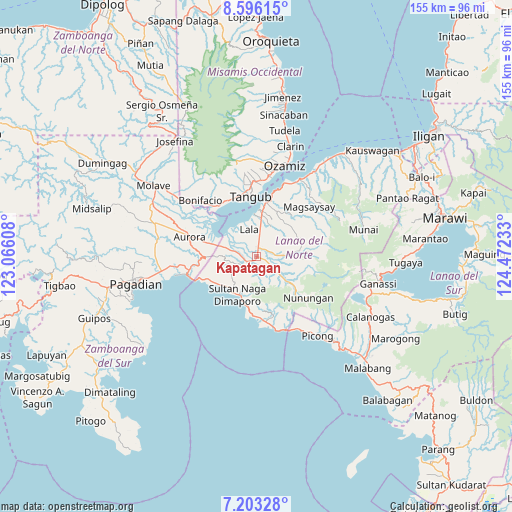
Kapatagan GPS coordinates[2]
7° 54' 1.08" North, 123° 46' 9.12" East
| Map corner | latitude | longitude |
|---|---|---|
| Upper-left | 8.59615°, | 123.06608° |
| Center: | 7.9003°, | 123.7692° |
| Lower-right: | 7.20328°, | 124.47233° |
| Map W x H: | 154.9×154.9 km | = 96.3×96.3mi |
| max Lat: | 20.78733° ⇑83.5% North |
| Kapatagan: | 7.9003° |
| min Lat: | ⇓16.5% South 4.65442° |
| min Long | Kapatagan | max Long |
| 117.04868° | 123.7692° | 126.58417° |
| W 67.4%⇐ | ⇒32.6% E |
Elevation
Elevation of Kapatagan is 18 m = 59 ft, and this is 69.9 m = 229 ft below average elevation for this country.
| Max E: |
2262 m = 7421 ft | 57.6% |
| Avg. | 87.9 m = 288 ft | |
| Kapatagan | 18 m = 59 ft | |
Min E: |
-2 m = -7 ft | 42.4% |
See also: Philippines elevation on elevation.city.
Geographical zone
Kapatagan is located in North Torrid zone (between Equator and Tropic of Cancer). Distance of Equator is 878.4 km =545.8 mi to South.| Distance of | km | miles | from Kapatagan |
|---|---|---|---|
| North Pole | 9128.6 | 5672.2 | to North |
| Arctic Circle | 6522.7 | 4053 | to North |
| Tropic Cancer | 1727.5 | 1073.4 | to North |
| Equator | 878.4 | 545.8 | to South |


Nearby cities:
15 places around Kapatagan: (largest is in red/bold)
• Balili
4 km =2.5 mi,  261°
261°
• Baroy
14.1 km =8.8 mi,  4°
4°
• Caromatan
13.1 km =8.1 mi,  207°
207°
• Lala
8.4 km =5.2 mi,  343°
343°
• Lanipao
6.2 km =3.9 mi,  7°
7°
• Lapining
9.3 km =5.8 mi,  285°
285°
• Maranding
2.7 km =1.7 mi, 5°
• Margos
12.6 km =7.8 mi, 286°
• Panalo-on
2.8 km =1.7 mi,  310°
310°
• Pualas
15.6 km =9.7 mi,  33°
33°
• Rebe
5.2 km =3.2 mi,  80°
80°
• Salvador
8.2 km =5.1 mi,  93°
93°
• Sapad
9 km =5.6 mi,  128°
128°
• Sumalig
16 km =9.9 mi, 312°
• Taguitic
15.8 km =9.8 mi, 285°
Sources, notices
• [Note1] Compared only with cities in Philippines existing in our database
• [Src1] Map data: © OpenStreetMap contributors (CC-BY-SA)
• [Src2] Other city data from geonames.org with taken over terms of usage.
• [Src3] Geographical zone / Annual Mean Temperature by Robert A. Rohde @ Wikipedia
