Matiao geodata
Matiao (Davao) is a populated place; located in Philippines in Asia/Manila (GMT+8) time zone. With population of 2,814 people, there are 2768 cities with bigger population in this country. Compared to other cities in Philippines, 90.8% of cities are located further ↑North; 97.2% of cities are located further ←West and 62.8% of cities have higher elevation than Matiao. Note1


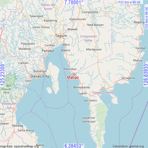
Matiao GPS coordinates[2]
7° 4' 58.08" North, 125° 56' 10.32" East
| Map corner | latitude | longitude |
|---|---|---|
| Upper-left | 7.78001°, | 125.23308° |
| Center: | 7.0828°, | 125.9362° |
| Lower-right: | 6.38453°, | 126.63933° |
| Map W x H: | 155.2×155.2 km | = 96.4×96.4mi |
| max Lat: | 20.78733° ⇑90.8% North |
| Matiao: | 7.0828° |
| min Lat: | ⇓9.2% South 4.65442° |
| min Long | Matiao | max Long |
| 117.04868° | 125.9362° | 126.58417° |
| W 97.2%⇐ | ⇒2.8% E |
Elevation
Elevation of Matiao is 15 m = 49 ft, and this is 72.9 m = 239 ft below average elevation for this country.
| Max E: |
2262 m = 7421 ft | 62.8% |
| Avg. | 87.9 m = 288 ft | |
| Matiao | 15 m = 49 ft | |
Min E: |
-2 m = -7 ft | 37.2% |
See also: Philippines elevation on elevation.city.
Geographical zone
Matiao is located in North Torrid zone (between Equator and Tropic of Cancer). Distance of Equator is 787.5 km =489.3 mi to South.| Distance of | km | miles | from Matiao |
|---|---|---|---|
| North Pole | 9219.5 | 5728.7 | to North |
| Arctic Circle | 6613.6 | 4109.5 | to North |
| Tropic Cancer | 1818.4 | 1129.9 | to North |
| Equator | 787.5 | 489.3 | to South |


Nearby cities:
15 places around Matiao: (largest is in red/bold)
• Aumbay
17 km =10.6 mi,  277°
277°
• Banaybanay
16.1 km =10 mi,  146°
146°
• Bungabon
17 km =10.6 mi,  335°
335°
• Ilangay
22.7 km =14.1 mi, 146°
• Linao
9.5 km =5.9 mi,  139°
139°
• Lupon
22.1 km =13.7 mi,  158°
158°
• Magnaga
10.7 km =6.6 mi,  333°
333°
• Pandasan
24.1 km =15 mi, 337°
• Panikian
12.6 km =7.8 mi,  129°
129°
• Pantukan
9.8 km =6.1 mi, 335°
• San Antonio
22.1 km =13.7 mi, 280°
• Tagdanua
14.7 km =9.1 mi, 336°
• Tagnanan
24.6 km =15.3 mi, 335°
• Tibagon
18.5 km =11.5 mi, 334°
• Tombongon
1.4 km =0.9 mi,  106°
106°
Sources, notices
• [Note1] Compared only with cities in Philippines existing in our database
• [Src1] Map data: © OpenStreetMap contributors (CC-BY-SA)
• [Src2] Other city data from geonames.org with taken over terms of usage.
• [Src3] Geographical zone / Annual Mean Temperature by Robert A. Rohde @ Wikipedia
