Molundo geodata
Molundo (Autonomous Region in Muslim Mindanao) is a seat of a third-order administrative division; located in Philippines in Asia/Manila (GMT+8) time zone. In our database, there are 4166 cities with bigger population. Compared to other cities in Philippines, 83.2% of cities are located further ↑North; 76.8% of cities are located further ←West and 97.7% of cities have lower elevation than Molundo. Note1
Administrative division(s):
- Level 1: Autonomous Region in Muslim Mindanao
- Level 2: Province of Lanao del Sur
- Level 3: Buadiposo-Buntong


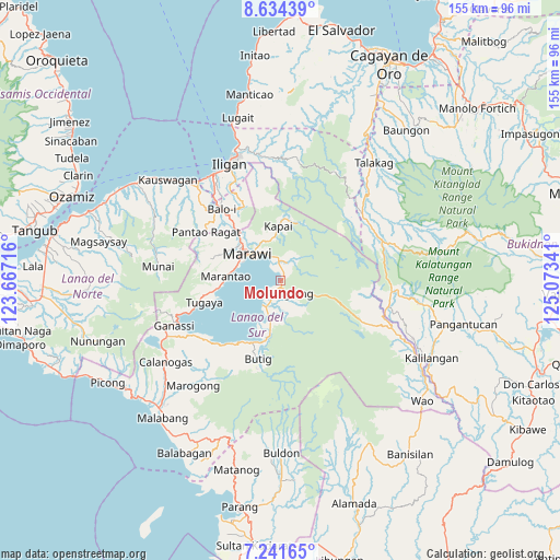
Molundo GPS coordinates[2]
7° 56' 18.996" North, 124° 22' 13.008" East
| Map corner | latitude | longitude |
|---|---|---|
| Upper-left | 8.63439°, | 123.66716° |
| Center: | 7.93861°, | 124.37028° |
| Lower-right: | 7.24165°, | 125.07341° |
| Map W x H: | 154.9×154.9 km | = 96.3×96.3mi |
| max Lat: | 20.78733° ⇑83.2% North |
| Molundo: | 7.93861° |
| min Lat: | ⇓16.8% South 4.65442° |
| min Long | Molundo | max Long |
| 117.04868° | 124.37028° | 126.58417° |
| W 76.8%⇐ | ⇒23.2% E |
Elevation
Elevation of Molundo is 710 m = 2329 ft, and this is 622.1 m = 2041 ft above average elevation for this country.
| Max E: |
2262 m = 7421 ft | 2.3% |
| Molundo | 710 m 2329 ft | |
| Avg. | 87.9 m = 288 ft | |
Min E: |
-2 m = -7 ft | 97.7% |
See also: Philippines elevation on elevation.city.
Geographical zone
Molundo is located in North Torrid zone (between Equator and Tropic of Cancer). Distance of Equator is 882.7 km =548.5 mi to South.| Distance of | km | miles | from Molundo |
|---|---|---|---|
| North Pole | 9124.4 | 5669.6 | to North |
| Arctic Circle | 6518.5 | 4050.4 | to North |
| Tropic Cancer | 1723.2 | 1070.7 | to North |
| Equator | 882.7 | 548.5 | to South |


Nearby cities:
15 places around Molundo: (largest is in red/bold)
• Balindong
18.9 km =11.7 mi,  262°
262°
• Buadiposo-Buntong
3.4 km =2.1 mi,  24°
24°
• Ditsaan
5 km =3.1 mi,  334°
334°
• Kalanganan
21.1 km =13.1 mi,  319°
319°
• Lumbatan
21.2 km =13.2 mi,  216°
216°
• Lumbayanague
20 km =12.4 mi,  209°
209°
• Marantao
15.1 km =9.4 mi,  274°
274°
• Marawi City
11.9 km =7.4 mi,  307°
307°
• Masiu
15.3 km =9.5 mi,  202°
202°
• Pantar
18.8 km =11.7 mi, 318°
• Pawak
15.2 km =9.4 mi,  304°
304°
• Ramain
4.5 km =2.8 mi, 322°
• Saguiaran
15.2 km =9.4 mi, 313°
• Tamparan
7.8 km =4.8 mi, 211°
• Tugaya
22.5 km =14 mi,  253°
253°
Sources, notices
• [Note1] Compared only with cities in Philippines existing in our database
• [Src1] Map data: © OpenStreetMap contributors (CC-BY-SA)
• [Src2] Other city data from geonames.org with taken over terms of usage.
• [Src3] Geographical zone / Annual Mean Temperature by Robert A. Rohde @ Wikipedia
