Kalanganan geodata
Kalanganan (Northern Mindanao) is a populated place; located in Philippines in Asia/Manila (GMT+8) time zone. With population of 2,331 people, there are 3607 cities with bigger population in this country. Compared to other cities in Philippines, 81.8% of cities are located further ↑North; 74.5% of cities are located further ←West and 96% of cities have lower elevation than Kalanganan. Note1
Administrative division(s):
- Level 1: Northern Mindanao
- Level 2: Province of Lanao del Norte
- Level 3: Pantar


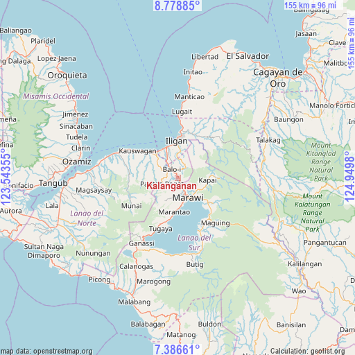
Kalanganan GPS coordinates[2]
8° 4' 59.988" North, 124° 14' 48.012" East
| Map corner | latitude | longitude |
|---|---|---|
| Upper-left | 8.77885°, | 123.54355° |
| Center: | 8.08333°, | 124.24667° |
| Lower-right: | 7.38661°, | 124.9498° |
| Map W x H: | 154.8×154.8 km | = 96.2×96.2mi |
| max Lat: | 20.78733° ⇑81.8% North |
| Kalanganan: | 8.08333° |
| min Lat: | ⇓18.2% South 4.65442° |
| min Long | Kalanganan | max Long |
| 117.04868° | 124.24667° | 126.58417° |
| W 74.5%⇐ | ⇒25.5% E |
Elevation
Elevation of Kalanganan is 507 m = 1663 ft, and this is 419.1 m = 1375 ft above average elevation for this country.
| Max E: |
2262 m = 7421 ft | 4% |
| Kalanganan | 507 m 1663 ft | |
| Avg. | 87.9 m = 288 ft | |
Min E: |
-2 m = -7 ft | 96% |
See also: Philippines elevation on elevation.city.
Geographical zone
Kalanganan is located in North Torrid zone (between Equator and Tropic of Cancer). Distance of Equator is 898.8 km =558.5 mi to South.| Distance of | km | miles | from Kalanganan |
|---|---|---|---|
| North Pole | 9108.3 | 5659.6 | to North |
| Arctic Circle | 6502.4 | 4040.4 | to North |
| Tropic Cancer | 1707.1 | 1060.7 | to North |
| Equator | 898.8 | 558.5 | to South |


Nearby cities:
15 places around Kalanganan: (largest is in red/bold)
• Boroon
13.5 km =8.4 mi,  325°
325°
• Dimayon
10.8 km =6.7 mi,  260°
260°
• Linamon
14.7 km =9.1 mi,  321°
321°
• Mamungan
4.9 km =3 mi, 320°
• Mantampay
9.8 km =6.1 mi,  340°
340°
• Marantao
14.9 km =9.3 mi,  185°
185°
• Marawi City
9.8 km =6.1 mi,  155°
155°
• Maria Cristina
10.3 km =6.4 mi, 332°
• Matungao
10.8 km =6.7 mi,  302°
302°
• Nañgka
11.6 km =7.2 mi, 323°
• Pantao-Ragat
12.5 km =7.8 mi,  270°
270°
• Pantar
2.3 km =1.4 mi,  146°
146°
• Pawak
7.5 km =4.7 mi,  171°
171°
• Poona-Piagapo
14.3 km =8.9 mi, 270°
• Saguiaran
6.2 km =3.9 mi, 155°
Sources, notices
• [Note1] Compared only with cities in Philippines existing in our database
• [Src1] Map data: © OpenStreetMap contributors (CC-BY-SA)
• [Src2] Other city data from geonames.org with taken over terms of usage.
• [Src3] Geographical zone / Annual Mean Temperature by Robert A. Rohde @ Wikipedia
