Pantar geodata
Pantar (Northern Mindanao) is a seat of a third-order administrative division; located in Philippines in Asia/Manila (GMT+8) time zone. In our database, there are 4166 cities with bigger population. Compared to other cities in Philippines, 82% of cities are located further ↑North; 74.7% of cities are located further ←West and 96.9% of cities have lower elevation than Pantar. Note1
Administrative division(s):
- Level 1: Northern Mindanao
- Level 2: Province of Lanao del Norte
- Level 3: Pantar


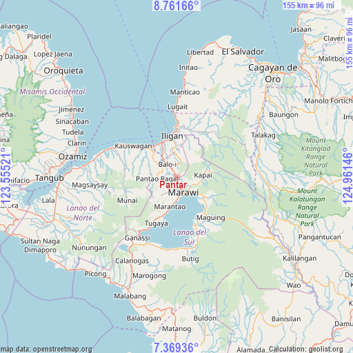
Pantar GPS coordinates[2]
8° 3' 57.996" North, 124° 15' 29.988" East
| Map corner | latitude | longitude |
|---|---|---|
| Upper-left | 8.76166°, | 123.55521° |
| Center: | 8.06611°, | 124.25833° |
| Lower-right: | 7.36936°, | 124.96146° |
| Map W x H: | 154.8×154.8 km | = 96.2×96.2mi |
| max Lat: | 20.78733° ⇑82% North |
| Pantar: | 8.06611° |
| min Lat: | ⇓18% South 4.65442° |
| min Long | Pantar | max Long |
| 117.04868° | 124.25833° | 126.58417° |
| W 74.7%⇐ | ⇒25.3% E |
Elevation
Elevation of Pantar is 592 m = 1942 ft, and this is 504.1 m = 1654 ft above average elevation for this country.
| Max E: |
2262 m = 7421 ft | 3.1% |
| Pantar | 592 m 1942 ft | |
| Avg. | 87.9 m = 288 ft | |
Min E: |
-2 m = -7 ft | 96.9% |
See also: Philippines elevation on elevation.city.
Geographical zone
Pantar is located in North Torrid zone (between Equator and Tropic of Cancer). Distance of Equator is 896.9 km =557.3 mi to South.| Distance of | km | miles | from Pantar |
|---|---|---|---|
| North Pole | 9110.2 | 5660.8 | to North |
| Arctic Circle | 6504.3 | 4041.6 | to North |
| Tropic Cancer | 1709.1 | 1062 | to North |
| Equator | 896.9 | 557.3 | to South |


Nearby cities:
15 places around Pantar: (largest is in red/bold)
• Dimayon
11.9 km =7.4 mi,  270°
270°
• Ditsaan
14.1 km =8.8 mi,  133°
133°
• Kalanganan
2.3 km =1.4 mi,  326°
326°
• Mamungan
7.2 km =4.5 mi,  322°
322°
• Mantampay
12.1 km =7.5 mi,  337°
337°
• Marantao
13.2 km =8.2 mi,  192°
192°
• Marawi City
7.5 km =4.7 mi,  157°
157°
• Maria Cristina
12.6 km =7.8 mi, 331°
• Matungao
13 km =8.1 mi,  306°
306°
• Nañgka
13.9 km =8.6 mi, 323°
• Pantao-Ragat
13.9 km =8.6 mi,  277°
277°
• Pawak
5.5 km =3.4 mi,  182°
182°
• Poona-Piagapo
15.7 km =9.8 mi, 276°
• Ramain
14.3 km =8.9 mi,  137°
137°
• Saguiaran
3.9 km =2.4 mi, 160°
Sources, notices
• [Note1] Compared only with cities in Philippines existing in our database
• [Src1] Map data: © OpenStreetMap contributors (CC-BY-SA)
• [Src2] Other city data from geonames.org with taken over terms of usage.
• [Src3] Geographical zone / Annual Mean Temperature by Robert A. Rohde @ Wikipedia
