Kapaya geodata
Kapaya (Soccsksargen) is a populated place; located in Philippines in Asia/Manila (GMT+8) time zone. With population of 4,201 people, there are 1629 cities with bigger population in this country. Compared to other cities in Philippines, 95.3% of cities are located further ↑North; 79.9% of cities are located further ←West and 83.6% of cities have lower elevation than Kapaya. Note1
Administrative division(s):
- Level 1: Soccsksargen
- Level 2: Province of Sultan Kudarat
- Level 3: Bagumbayan


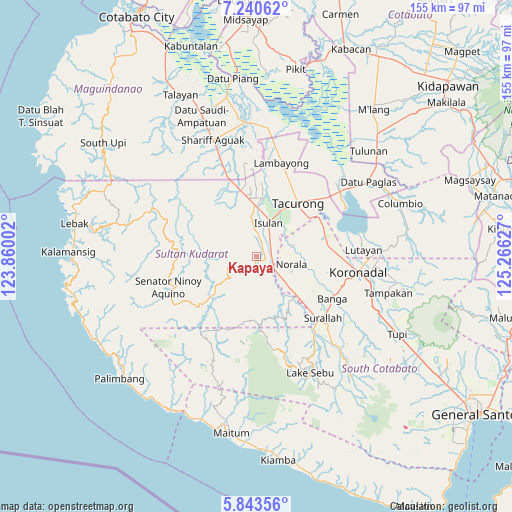
Kapaya GPS coordinates[2]
6° 32' 33.288" North, 124° 33' 47.304" East
| Map corner | latitude | longitude |
|---|---|---|
| Upper-left | 7.24062°, | 123.86002° |
| Center: | 6.54258°, | 124.56314° |
| Lower-right: | 5.84356°, | 125.26627° |
| Map W x H: | 155.3×155.3 km | = 96.5×96.5mi |
| max Lat: | 20.78733° ⇑95.3% North |
| Kapaya: | 6.54258° |
| min Lat: | ⇓4.7% South 4.65442° |
| min Long | Kapaya | max Long |
| 117.04868° | 124.56314° | 126.58417° |
| W 79.9%⇐ | ⇒20.1% E |
Elevation
Elevation of Kapaya is 122 m = 400 ft, and this is 34.1 m = 112 ft above average elevation for this country.
| Max E: |
2262 m = 7421 ft | 16.4% |
| Kapaya | 122 m 400 ft | |
| Avg. | 87.9 m = 288 ft | |
Min E: |
-2 m = -7 ft | 83.6% |
See also: Philippines elevation on elevation.city.
Geographical zone
Kapaya is located in North Torrid zone (between Equator and Tropic of Cancer). Distance of Equator is 727.5 km =452 mi to South.| Distance of | km | miles | from Kapaya |
|---|---|---|---|
| North Pole | 9279.6 | 5766.1 | to North |
| Arctic Circle | 6673.7 | 4146.8 | to North |
| Tropic Cancer | 1878.5 | 1167.2 | to North |
| Equator | 727.5 | 452 | to South |


Nearby cities:
15 places around Kapaya: (largest is in red/bold)
• Biwang
7.4 km =4.6 mi,  342°
342°
• Busok
5.6 km =3.5 mi,  133°
133°
• Daguma
6.8 km =4.2 mi,  6°
6°
• Dansuli
11.1 km =6.9 mi, 11°
• Dukay
13.8 km =8.6 mi,  357°
357°
• Dumaguil
13.2 km =8.2 mi,  49°
49°
• Esperanza
12.5 km =7.8 mi,  113°
113°
• Isulan
10.7 km =6.6 mi,  25°
25°
• Kolumbug
5.4 km =3.4 mi, 112°
• Kudanding
9.2 km =5.7 mi,  56°
56°
• Lapuz
9.2 km =5.7 mi, 125°
• Liberty
8 km =5 mi, 108°
• Norala
10.8 km =6.7 mi,  101°
101°
• Panay
9.7 km =6 mi,  121°
121°
• Tuka
3.8 km =2.4 mi, 134°
Sources, notices
• [Note1] Compared only with cities in Philippines existing in our database
• [Src1] Map data: © OpenStreetMap contributors (CC-BY-SA)
• [Src2] Other city data from geonames.org with taken over terms of usage.
• [Src3] Geographical zone / Annual Mean Temperature by Robert A. Rohde @ Wikipedia
