Tuka geodata
Tuka (Soccsksargen) is a populated place; located in Philippines in Asia/Manila (GMT+8) time zone. With population of 4,003 people, there are 1728 cities with bigger population in this country. Compared to other cities in Philippines, 95.5% of cities are located further ↑North; 80.6% of cities are located further ←West and 80.6% of cities have lower elevation than Tuka. Note1
Administrative division(s):
- Level 1: Soccsksargen
- Level 2: Province of Sultan Kudarat
- Level 3: Bagumbayan


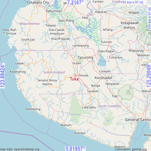
Tuka GPS coordinates[2]
6° 31' 7.032" North, 124° 35' 14.496" East
| Map corner | latitude | longitude |
|---|---|---|
| Upper-left | 7.2167°, | 123.88424° |
| Center: | 6.51862°, | 124.58736° |
| Lower-right: | 5.81957°, | 125.29049° |
| Map W x H: | 155.3×155.3 km | = 96.5×96.5mi |
| max Lat: | 20.78733° ⇑95.5% North |
| Tuka: | 6.51862° |
| min Lat: | ⇓4.5% South 4.65442° |
| min Long | Tuka | max Long |
| 117.04868° | 124.58736° | 126.58417° |
| W 80.6%⇐ | ⇒19.4% E |
Elevation
Elevation of Tuka is 95 m = 312 ft, and this is 7.1 m = 23 ft above average elevation for this country.
| Max E: |
2262 m = 7421 ft | 19.4% |
| Tuka | 95 m 312 ft | |
| Avg. | 87.9 m = 288 ft | |
Min E: |
-2 m = -7 ft | 80.6% |
See also: Philippines elevation on elevation.city.
Geographical zone
Tuka is located in North Torrid zone (between Equator and Tropic of Cancer). Distance of Equator is 724.8 km =450.4 mi to South.| Distance of | km | miles | from Tuka |
|---|---|---|---|
| North Pole | 9282.3 | 5767.8 | to North |
| Arctic Circle | 6676.4 | 4148.5 | to North |
| Tropic Cancer | 1881.1 | 1168.9 | to North |
| Equator | 724.8 | 450.4 | to South |


Nearby cities:
15 places around Tuka: (largest is in red/bold)
• Biwang
10.8 km =6.7 mi,  333°
333°
• Busok
1.8 km =1.1 mi,  129°
129°
• Daguma
9.6 km =6 mi,  348°
348°
• Esperanza
9.1 km =5.7 mi,  104°
104°
• Guinsang-an
12.3 km =7.6 mi,  118°
118°
• Isulan
12.5 km =7.8 mi,  8°
8°
• Kapaya
3.8 km =2.4 mi,  314°
314°
• Kolumbug
2.4 km =1.5 mi,  75°
75°
• Kudanding
9.2 km =5.7 mi,  33°
33°
• Lapuz
5.5 km =3.4 mi, 119°
• Liberty
4.9 km =3 mi,  88°
88°
• Manuel Roxas
12.2 km =7.6 mi, 134°
• Norala
7.9 km =4.9 mi, 86°
• Panay
6.1 km =3.8 mi,  113°
113°
• San Miguel
12.4 km =7.7 mi, 103°
Sources, notices
• [Note1] Compared only with cities in Philippines existing in our database
• [Src1] Map data: © OpenStreetMap contributors (CC-BY-SA)
• [Src2] Other city data from geonames.org with taken over terms of usage.
• [Src3] Geographical zone / Annual Mean Temperature by Robert A. Rohde @ Wikipedia
