Mirpur Bhtoro geodata
Mirpur Bhtoro (Sindh) is a populated place; located in Pakistan in Asia/Karachi (GMT+5) time zone. With population of 8,866 people, there are 362 cities with bigger population in this country. Compared to other cities in Pakistan, 98.2% of cities are located further ↑North; 84.2% of cities are located further →East and 96.6% of cities have higher elevation than Mirpur Bhtoro. Note1


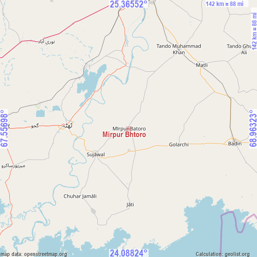
Mirpur Bhtoro GPS coordinates[2]
24° 43' 42.672" North, 68° 15' 36.36" East
| Map corner | latitude | longitude |
|---|---|---|
| Upper-left | 25.36552°, | 67.55698° |
| Center: | 24.72852°, | 68.2601° |
| Lower-right: | 24.08824°, | 68.96323° |
| Map W x H: | 142×142 km | = 88.2×88.2mi |
| max Lat: | 36.32162° ⇑98.2% North |
| Mirpur Bhtoro: | 24.72852° |
| min Lat: | ⇓1.8% South 24.14422° |
| min Long | Mirpur Bhtoro | max Long |
| 61.74573° | 68.2601° | 75.63372° |
| W 15.8%⇐ | ⇒84.2% E |
Elevation
Elevation of Mirpur Bhtoro is 12 m = 39 ft, and this is 333 m = 1093 ft below average elevation for this country.
| Max E: |
2732 m = 8963 ft | 96.6% |
| Avg. | 345 m = 1132 ft | |
| Mirpur Bhtoro | 12 m = 39 ft | |
Min E: |
3 m = 10 ft | 3.4% |
See also: Pakistan elevation on elevation.city.
Geographical zone
Mirpur Bhtoro is located in North temperate zone (between Tropic of Cancer and the Arctic Circle). Distance of this Northern Tropic circle is 143.6 km =89.2 mi to South.| Distance of | km | miles | from Mirpur Bhtoro |
|---|---|---|---|
| North Pole | 7257.5 | 4509.6 | to North |
| Arctic Circle | 4651.6 | 2890.4 | to North |
| Tropic Cancer | 143.6 | 89.2 | to South |
| Equator | 2749.6 | 1708.5 | to South |


Nearby cities:
15 places around Mirpur Bhtoro: (largest is in red/bold)
• Badin
58.8 km =36.5 mi,  97°
97°
• Bulri
17 km =10.6 mi,  25°
25°
• Chuhar Jamali
45.9 km =28.5 mi,  216°
216°
• Daromehar
10.9 km =6.8 mi,  311°
311°
• Gharo
68.2 km =42.4 mi,  271°
271°
• Jati
41.5 km =25.8 mi,  178°
178°
• Kario Ghanwar
35.9 km =22.3 mi,  75°
75°
• Kotri
71 km =44.1 mi,  3°
3°
• Matli
53.1 km =33 mi,  48°
48°
• Mirpur Sakro
67 km =41.6 mi,  252°
252°
• Nooriabad
68 km =42.3 mi,  316°
316°
• Rajo Khanani
66.3 km =41.2 mi,  64°
64°
• Talhar
58.6 km =36.4 mi,  72°
72°
• Tando Muhammad Khan
52.1 km =32.4 mi, 32°
• Thatta
34.1 km =21.2 mi, 273°
Sources, notices
• [Note1] Compared only with cities in Pakistan existing in our database
• [Src1] Map data: © OpenStreetMap contributors (CC-BY-SA)
• [Src2] Other city data from geonames.org with taken over terms of usage.
• [Src3] Geographical zone / Annual Mean Temperature by Robert A. Rohde @ Wikipedia
