Badin geodata
Badin (Sindh) is a seat of a second-order administrative division; located in Pakistan in Asia/Karachi (GMT+5) time zone. With population of 73,569 people, there are 90 cities with bigger population in this country. Compared to other cities in Pakistan, 98.6% of cities are located further ↑North; 71.6% of cities are located further →East and 95.9% of cities have higher elevation than Badin. Note1


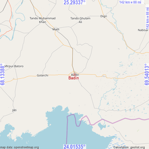
Badin GPS coordinates[2]
24° 39' 21.6" North, 68° 50' 13.2" East
| Map corner | latitude | longitude |
|---|---|---|
| Upper-left | 25.29337°, | 68.13388° |
| Center: | 24.656°, | 68.837° |
| Lower-right: | 24.01535°, | 69.54013° |
| Map W x H: | 142.1×142.1 km | = 88.3×88.3mi |
| max Lat: | 36.32162° ⇑98.6% North |
| Badin: | 24.656° |
| min Lat: | ⇓1.4% South 24.14422° |
| min Long | Badin | max Long |
| 61.74573° | 68.837° | 75.63372° |
| W 28.4%⇐ | ⇒71.6% E |
Elevation
Elevation of Badin is 13 m = 43 ft, and this is 332 m = 1089 ft below average elevation for this country.
| Max E: |
2732 m = 8963 ft | 95.9% |
| Avg. | 345 m = 1132 ft | |
| Badin | 13 m = 43 ft | |
Min E: |
3 m = 10 ft | 4.1% |
See also: Badin elevation on elevation.city.
Geographical zone
Badin is located in North temperate zone (between Tropic of Cancer and the Arctic Circle). Distance of this Northern Tropic circle is 135.6 km =84.3 mi to South.| Distance of | km | miles | from Badin |
|---|---|---|---|
| North Pole | 7265.6 | 4514.6 | to North |
| Arctic Circle | 4659.7 | 2895.4 | to North |
| Tropic Cancer | 135.6 | 84.3 | to South |
| Equator | 2741.5 | 1703.5 | to South |


Nearby cities:
15 places around Badin: (largest is in red/bold)
• Bulri
56 km =34.8 mi,  294°
294°
• Chamber
70.9 km =44.1 mi,  357°
357°
• Daromehar
68.1 km =42.3 mi,  282°
282°
• Digri
62.1 km =38.6 mi,  26°
26°
• Jati
66.7 km =41.4 mi,  239°
239°
• Kadhan
24.6 km =15.3 mi,  142°
142°
• Kario Ghanwar
28.9 km =18 mi,  305°
305°
• Matli
46.7 km =29 mi,  336°
336°
• Mirpur Bhtoro
58.8 km =36.5 mi, 277°
• Mirwah Gorchani
75.8 km =47.1 mi,  16°
16°
• Naukot
61.3 km =38.1 mi,  68°
68°
• Rajo Khanani
36.5 km =22.7 mi,  2°
2°
• Talhar
25.5 km =15.8 mi,  354°
354°
• Tando Bago
19.7 km =12.2 mi,  41°
41°
• Tando Muhammad Khan
60.2 km =37.4 mi,  329°
329°
Sources, notices
• [Note1] Compared only with cities in Pakistan existing in our database
• [Src1] Map data: © OpenStreetMap contributors (CC-BY-SA)
• [Src2] Other city data from geonames.org with taken over terms of usage.
• [Src3] Geographical zone / Annual Mean Temperature by Robert A. Rohde @ Wikipedia
