Jati geodata
Jati (Sindh) is a populated place; located in Pakistan in Asia/Karachi (GMT+5) time zone. With population of 9,152 people, there are 357 cities with bigger population in this country. Compared to other cities in Pakistan, 99.8% of cities are located further ↑North; 84% of cities are located further →East and 97.3% of cities have higher elevation than Jati. Note1


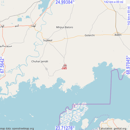
Jati GPS coordinates[2]
24° 21' 17.712" North, 68° 16' 2.352" East
| Map corner | latitude | longitude |
|---|---|---|
| Upper-left | 24.99384°, | 67.5642° |
| Center: | 24.35492°, | 68.26732° |
| Lower-right: | 23.71276°, | 68.97045° |
| Map W x H: | 142.4×142.4 km | = 88.5×88.5mi |
| max Lat: | 36.32162° ⇑99.8% North |
| Jati: | 24.35492° |
| min Lat: | ⇓0.2% South 24.14422° |
| min Long | Jati | max Long |
| 61.74573° | 68.26732° | 75.63372° |
| W 16%⇐ | ⇒84% E |
Elevation
Elevation of Jati is 11 m = 36 ft, and this is 334 m = 1096 ft below average elevation for this country.
| Max E: |
2732 m = 8963 ft | 97.3% |
| Avg. | 345 m = 1132 ft | |
| Jati | 11 m = 36 ft | |
Min E: |
3 m = 10 ft | 2.7% |
See also: Pakistan elevation on elevation.city.
Geographical zone
Jati is located in North temperate zone (between Tropic of Cancer and the Arctic Circle). Distance of this Northern Tropic circle is 102.1 km =63.4 mi to South.| Distance of | km | miles | from Jati |
|---|---|---|---|
| North Pole | 7299 | 4535.4 | to North |
| Arctic Circle | 4693.2 | 2916.2 | to North |
| Tropic Cancer | 102.1 | 63.4 | to South |
| Equator | 2708 | 1682.7 | to South |


Nearby cities:
15 places around Jati: (largest is in red/bold)
• Badin
66.7 km =41.4 mi,  59°
59°
• Bulri
57.3 km =35.6 mi,  6°
6°
• Chuhar Jamali
28.1 km =17.5 mi,  278°
278°
• Daromehar
49.6 km =30.8 mi,  349°
349°
• Gharo
81.3 km =50.5 mi,  301°
301°
• Kadhan
74 km =46 mi,  79°
79°
• Kario Ghanwar
60.9 km =37.8 mi,  34°
34°
• Keti Bandar
86 km =53.4 mi,  254°
254°
• Matli
86 km =53.4 mi, 27°
• Mirpur Bhtoro
41.5 km =25.8 mi,  358°
358°
• Mirpur Sakro
68.1 km =42.3 mi,  288°
288°
• Talhar
80.8 km =50.2 mi,  43°
43°
• Tando Bago
85.5 km =53.1 mi, 55°
• Tando Muhammad Khan
89.7 km =55.7 mi,  17°
17°
• Thatta
55.8 km =34.7 mi,  321°
321°
Sources, notices
• [Note1] Compared only with cities in Pakistan existing in our database
• [Src1] Map data: © OpenStreetMap contributors (CC-BY-SA)
• [Src2] Other city data from geonames.org with taken over terms of usage.
• [Src3] Geographical zone / Annual Mean Temperature by Robert A. Rohde @ Wikipedia
