Zelków geodata
Zelków (Lesser Poland) is a populated place; located in Poland in Europe/Warsaw (GMT+2) time zone. With population of 590 people, there are 3306 cities with bigger population in this country. Compared to other cities in Poland, 75.7% of cities are located further ↑North; 54.8% of cities are located further ←West and 94.4% of cities have lower elevation than Zelków. Note1


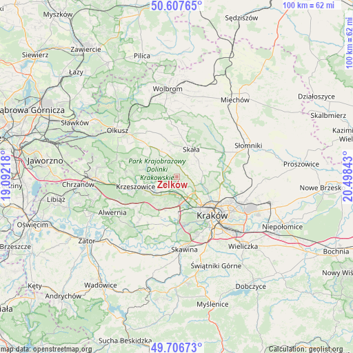
Zelków GPS coordinates[2]
50° 9' 33.516" North, 19° 47' 43.08" East
| Map corner | latitude | longitude |
|---|---|---|
| Upper-left | 50.60765°, | 19.09218° |
| Center: | 50.15931°, | 19.7953° |
| Lower-right: | 49.70673°, | 20.49843° |
| Map W x H: | 100.2×100.2 km | = 62.3×62.3mi |
| max Lat: | 54.83135° ⇑75.7% North |
| Zelków: | 50.15931° |
| min Lat: | ⇓24.3% South 49.21328° |
| min Long | Zelków | max Long |
| 14.20249° | 19.7953° | 24.03723° |
| W 54.8%⇐ | ⇒45.2% E |
Elevation
Elevation of Zelków is 402 m = 1319 ft, and this is 210.6 m = 691 ft above average elevation for this country.
| Max E: |
974 m = 3196 ft | 5.6% |
| Zelków | 402 m 1319 ft | |
| Avg. | 191.4 m = 628 ft | |
Min E: |
-3 m = -10 ft | 94.4% |
See also: Poland elevation on elevation.city.
Geographical zone
Zelków is located in North temperate zone (between Tropic of Cancer and the Arctic Circle). Distance of this North polar circle is 1824 km =1133.4 mi to North.| Distance of | km | miles | from Zelków |
|---|---|---|---|
| North Pole | 4429.9 | 2752.6 | to North |
| Arctic Circle | 1824 | 1133.4 | to North |
| Tropic Cancer | 2971.3 | 1846.3 | to South |
| Equator | 5577.2 | 3465.5 | to South |


Nearby cities:
15 places around Zelków: (largest is in red/bold)
• Bolechowice
1.2 km =0.7 mi,  188°
188°
• Brzezie
4.5 km =2.8 mi,  153°
153°
• Brzezinka
4.7 km =2.9 mi,  237°
237°
• Bębło
2.4 km =1.5 mi,  346°
346°
• Giebułtów
6.1 km =3.8 mi,  104°
104°
• Jerzmanowice
6.9 km =4.3 mi,  329°
329°
• Karniowice
1.5 km =0.9 mi,  229°
229°
• Kobylany
2.6 km =1.6 mi,  246°
246°
• Modlnica
5.9 km =3.7 mi,  123°
123°
• Modlniczka
6.3 km =3.9 mi,  137°
137°
• Rudawa
7.3 km =4.5 mi, 234°
• Tomaszowice
4.5 km =2.8 mi,  125°
125°
• Wielka Wieś
3.5 km =2.2 mi,  94°
94°
• Więckowice
3.3 km =2.1 mi,  222°
222°
• Zabierzów
5 km =3.1 mi,  177°
177°
Sources, notices
• [Note1] Compared only with cities in Poland existing in our database
• [Src1] Map data: © OpenStreetMap contributors (CC-BY-SA)
• [Src2] Other city data from geonames.org with taken over terms of usage.
• [Src3] Geographical zone / Annual Mean Temperature by Robert A. Rohde @ Wikipedia
