Bolechowice geodata
Bolechowice (Lesser Poland) is a populated place; located in Poland in Europe/Warsaw (GMT+2) time zone. With population of 1,515 people, there are 1831 cities with bigger population in this country. Compared to other cities in Poland, 76.1% of cities are located further ↑North; 54.7% of cities are located further ←West and 83.2% of cities have lower elevation than Bolechowice. Note1


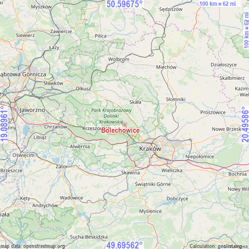
Bolechowice GPS coordinates[2]
50° 8' 53.916" North, 19° 47' 33.828" East
| Map corner | latitude | longitude |
|---|---|---|
| Upper-left | 50.59675°, | 19.08961° |
| Center: | 50.14831°, | 19.79273° |
| Lower-right: | 49.69562°, | 20.49586° |
| Map W x H: | 100.2×100.2 km | = 62.3×62.3mi |
| max Lat: | 54.83135° ⇑76.1% North |
| Bolechowice: | 50.14831° |
| min Lat: | ⇓23.9% South 49.21328° |
| min Long | Bolechowice | max Long |
| 14.20249° | 19.79273° | 24.03723° |
| W 54.7%⇐ | ⇒45.3% E |
Elevation
Elevation of Bolechowice is 281 m = 922 ft, and this is 89.6 m = 294 ft above average elevation for this country.
| Max E: |
974 m = 3196 ft | 16.8% |
| Bolechowice | 281 m 922 ft | |
| Avg. | 191.4 m = 628 ft | |
Min E: |
-3 m = -10 ft | 83.2% |
See also: Poland elevation on elevation.city.
Geographical zone
Bolechowice is located in North temperate zone (between Tropic of Cancer and the Arctic Circle). Distance of this North polar circle is 1825.2 km =1134.1 mi to North.| Distance of | km | miles | from Bolechowice |
|---|---|---|---|
| North Pole | 4431.1 | 2753.4 | to North |
| Arctic Circle | 1825.2 | 1134.1 | to North |
| Tropic Cancer | 2970.1 | 1845.5 | to South |
| Equator | 5576 | 3464.8 | to South |


Nearby cities:
15 places around Bolechowice: (largest is in red/bold)
• Balice
6.7 km =4.2 mi,  178°
178°
• Brzezie
3.6 km =2.2 mi,  142°
142°
• Brzezinka
4 km =2.5 mi,  250°
250°
• Bębło
3.6 km =2.2 mi,  353°
353°
• Giebułtów
6.1 km =3.8 mi,  92°
92°
• Karniowice
1 km =0.6 mi,  283°
283°
• Kobylany
2.2 km =1.4 mi,  274°
274°
• Modlnica
5.5 km =3.4 mi,  112°
112°
• Modlniczka
5.6 km =3.5 mi,  127°
127°
• Rudawa
6.5 km =4 mi,  242°
242°
• Tomaszowice
4.1 km =2.5 mi, 110°
• Wielka Wieś
3.8 km =2.4 mi,  75°
75°
• Więckowice
2.4 km =1.5 mi, 239°
• Zabierzów
3.8 km =2.4 mi,  174°
174°
• Zelków
1.2 km =0.7 mi,  8°
8°
Sources, notices
• [Note1] Compared only with cities in Poland existing in our database
• [Src1] Map data: © OpenStreetMap contributors (CC-BY-SA)
• [Src2] Other city data from geonames.org with taken over terms of usage.
• [Src3] Geographical zone / Annual Mean Temperature by Robert A. Rohde @ Wikipedia
