Karniowice geodata
Karniowice (Lesser Poland) is a populated place; located in Poland in Europe/Warsaw (GMT+2) time zone. With population of 841 people, there are 2780 cities with bigger population in this country. Compared to other cities in Poland, 76% of cities are located further ↑North; 54.4% of cities are located further ←West and 85.4% of cities have lower elevation than Karniowice. Note1


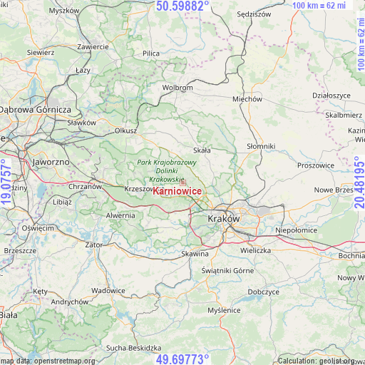
Karniowice GPS coordinates[2]
50° 9' 1.44" North, 19° 46' 43.752" East
| Map corner | latitude | longitude |
|---|---|---|
| Upper-left | 50.59882°, | 19.0757° |
| Center: | 50.1504°, | 19.77882° |
| Lower-right: | 49.69773°, | 20.48195° |
| Map W x H: | 100.2×100.2 km | = 62.3×62.3mi |
| max Lat: | 54.83135° ⇑76% North |
| Karniowice: | 50.1504° |
| min Lat: | ⇓24% South 49.21328° |
| min Long | Karniowice | max Long |
| 14.20249° | 19.77882° | 24.03723° |
| W 54.4%⇐ | ⇒45.6% E |
Elevation
Elevation of Karniowice is 292 m = 958 ft, and this is 100.6 m = 330 ft above average elevation for this country.
| Max E: |
974 m = 3196 ft | 14.6% |
| Karniowice | 292 m 958 ft | |
| Avg. | 191.4 m = 628 ft | |
Min E: |
-3 m = -10 ft | 85.4% |
See also: Poland elevation on elevation.city.
Geographical zone
Karniowice is located in North temperate zone (between Tropic of Cancer and the Arctic Circle). Distance of this North polar circle is 1825 km =1134 mi to North.| Distance of | km | miles | from Karniowice |
|---|---|---|---|
| North Pole | 4430.9 | 2753.2 | to North |
| Arctic Circle | 1825 | 1134 | to North |
| Tropic Cancer | 2970.3 | 1845.7 | to South |
| Equator | 5576.2 | 3464.9 | to South |


Nearby cities:
15 places around Karniowice: (largest is in red/bold)
• Balice
7 km =4.3 mi,  170°
170°
• Bolechowice
1 km =0.6 mi,  103°
103°
• Brzezie
4.4 km =2.7 mi,  134°
134°
• Brzezinka
3.2 km =2 mi,  241°
241°
• Bębło
3.4 km =2.1 mi,  10°
10°
• Giebułtów
7.1 km =4.4 mi,  94°
94°
• Kobylany
1.2 km =0.7 mi,  266°
266°
• Modlnica
6.5 km =4 mi,  110°
110°
• Modlniczka
6.6 km =4.1 mi,  123°
123°
• Rudawa
5.7 km =3.5 mi, 235°
• Tomaszowice
5.1 km =3.2 mi, 108°
• Wielka Wieś
4.7 km =2.9 mi,  81°
81°
• Więckowice
1.8 km =1.1 mi,  216°
216°
• Zabierzów
4.2 km =2.6 mi,  161°
161°
• Zelków
1.5 km =0.9 mi,  49°
49°
Sources, notices
• [Note1] Compared only with cities in Poland existing in our database
• [Src1] Map data: © OpenStreetMap contributors (CC-BY-SA)
• [Src2] Other city data from geonames.org with taken over terms of usage.
• [Src3] Geographical zone / Annual Mean Temperature by Robert A. Rohde @ Wikipedia
