Rudawa geodata
Rudawa (Lesser Poland) is a populated place; located in Poland in Europe/Warsaw (GMT+2) time zone. With population of 1,720 people, there are 1666 cities with bigger population in this country. Compared to other cities in Poland, 77.1% of cities are located further ↑North; 52.9% of cities are located further ←West and 78.5% of cities have lower elevation than Rudawa. Note1


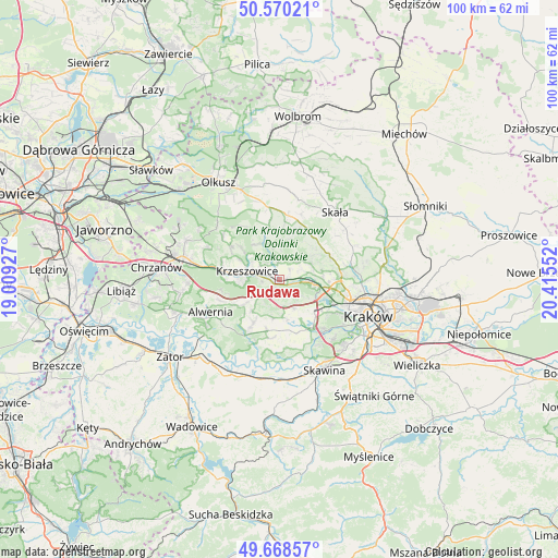
Rudawa GPS coordinates[2]
50° 7' 17.436" North, 19° 42' 44.604" East
| Map corner | latitude | longitude |
|---|---|---|
| Upper-left | 50.57021°, | 19.00927° |
| Center: | 50.12151°, | 19.71239° |
| Lower-right: | 49.66857°, | 20.41552° |
| Map W x H: | 100.3×100.3 km | = 62.3×62.3mi |
| max Lat: | 54.83135° ⇑77.1% North |
| Rudawa: | 50.12151° |
| min Lat: | ⇓22.9% South 49.21328° |
| min Long | Rudawa | max Long |
| 14.20249° | 19.71239° | 24.03723° |
| W 52.9%⇐ | ⇒47.1% E |
Elevation
Elevation of Rudawa is 259 m = 850 ft, and this is 67.6 m = 222 ft above average elevation for this country.
| Max E: |
974 m = 3196 ft | 21.5% |
| Rudawa | 259 m 850 ft | |
| Avg. | 191.4 m = 628 ft | |
Min E: |
-3 m = -10 ft | 78.5% |
See also: Poland elevation on elevation.city.
Geographical zone
Rudawa is located in North temperate zone (between Tropic of Cancer and the Arctic Circle). Distance of this North polar circle is 1828.2 km =1136 mi to North.| Distance of | km | miles | from Rudawa |
|---|---|---|---|
| North Pole | 4434.1 | 2755.2 | to North |
| Arctic Circle | 1828.2 | 1136 | to North |
| Tropic Cancer | 2967.1 | 1843.7 | to South |
| Equator | 5573 | 3462.9 | to South |


Nearby cities:
15 places around Rudawa: (largest is in red/bold)
• Aleksandrowice
5.8 km =3.6 mi,  139°
139°
• Balice
6.9 km =4.3 mi,  122°
122°
• Bolechowice
6.5 km =4 mi,  62°
62°
• Brzezinka
2.5 km =1.6 mi,  49°
49°
• Brzoskwinia
3 km =1.9 mi,  179°
179°
• Czułów
6.9 km =4.3 mi,  186°
186°
• Karniowice
5.7 km =3.5 mi, 55°
• Kobylany
4.7 km =2.9 mi, 48°
• Krzeszowice
6.2 km =3.9 mi,  292°
292°
• Mników
6.9 km =4.3 mi,  171°
171°
• Morawica
5.9 km =3.7 mi,  150°
150°
• Nielepice
1.7 km =1.1 mi,  208°
208°
• Tenczynek
7.1 km =4.4 mi,  268°
268°
• Więckowice
4.1 km =2.5 mi, 64°
• Zabierzów
6.1 km =3.8 mi,  97°
97°
Sources, notices
• [Note1] Compared only with cities in Poland existing in our database
• [Src1] Map data: © OpenStreetMap contributors (CC-BY-SA)
• [Src2] Other city data from geonames.org with taken over terms of usage.
• [Src3] Geographical zone / Annual Mean Temperature by Robert A. Rohde @ Wikipedia
