Włosienica geodata
Włosienica (Lesser Poland) is a populated place; located in Poland in Europe/Warsaw (GMT+2) time zone. With population of 1,491 people, there are 1885 cities with bigger population in this country. Compared to other cities in Poland, 81.5% of cities are located further ↑North; 54.2% of cities are located further →East and 71.4% of cities have lower elevation than Włosienica. Note1


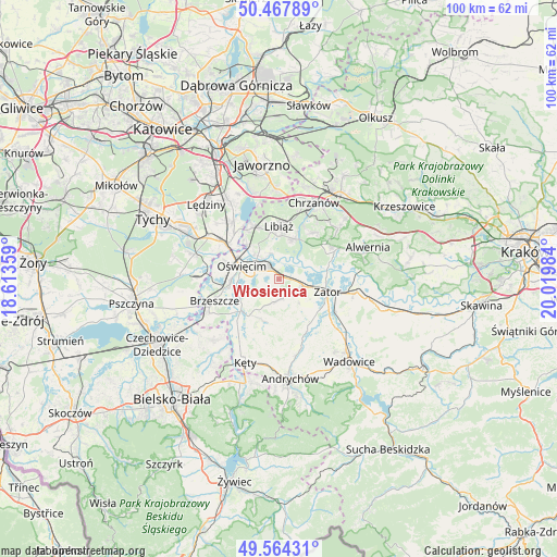
Włosienica GPS coordinates[2]
50° 1' 5.592" North, 19° 19' 0.156" East
| Map corner | latitude | longitude |
|---|---|---|
| Upper-left | 50.46789°, | 18.61359° |
| Center: | 50.01822°, | 19.31671° |
| Lower-right: | 49.56431°, | 20.01984° |
| Map W x H: | 100.5×100.5 km | = 62.4×62.4mi |
| max Lat: | 54.83135° ⇑81.5% North |
| Włosienica: | 50.01822° |
| min Lat: | ⇓18.5% South 49.21328° |
| min Long | Włosienica | max Long |
| 14.20249° | 19.31671° | 24.03723° |
| W 45.8%⇐ | ⇒54.2% E |
Elevation
Elevation of Włosienica is 233 m = 764 ft, and this is 41.6 m = 136 ft above average elevation for this country.
| Max E: |
974 m = 3196 ft | 28.6% |
| Włosienica | 233 m 764 ft | |
| Avg. | 191.4 m = 628 ft | |
Min E: |
-3 m = -10 ft | 71.4% |
See also: Poland elevation on elevation.city.
Geographical zone
Włosienica is located in North temperate zone (between Tropic of Cancer and the Arctic Circle). Distance of this North polar circle is 1839.7 km =1143.1 mi to North.| Distance of | km | miles | from Włosienica |
|---|---|---|---|
| North Pole | 4445.6 | 2762.4 | to North |
| Arctic Circle | 1839.7 | 1143.1 | to North |
| Tropic Cancer | 2955.6 | 1836.5 | to South |
| Equator | 5561.5 | 3455.8 | to South |


Nearby cities:
15 places around Włosienica: (largest is in red/bold)
• Babice
9.3 km =5.8 mi,  296°
296°
• Brzezinka
9.4 km =5.8 mi,  286°
286°
• Grojec
7 km =4.3 mi,  234°
234°
• Jankowice
9.4 km =5.8 mi,  72°
72°
• Mętków
5.7 km =3.5 mi,  47°
47°
• Osiek
8.4 km =5.2 mi,  206°
206°
• Oświęcim
7.8 km =4.8 mi,  283°
283°
• Polanka Wielka
3.8 km =2.4 mi,  169°
169°
• Poręba Wielka
2.5 km =1.6 mi,  251°
251°
• Przeciszów
4.4 km =2.7 mi,  107°
107°
• Rajsko
8.9 km =5.5 mi,  265°
265°
• Skidziń
9.5 km =5.9 mi,  242°
242°
• Zaborze
5.4 km =3.4 mi, 274°
• Zator
9 km =5.6 mi, 105°
• Żarki
7.6 km =4.7 mi,  19°
19°
Sources, notices
• [Note1] Compared only with cities in Poland existing in our database
• [Src1] Map data: © OpenStreetMap contributors (CC-BY-SA)
• [Src2] Other city data from geonames.org with taken over terms of usage.
• [Src3] Geographical zone / Annual Mean Temperature by Robert A. Rohde @ Wikipedia
