Rajsko geodata
Rajsko (Lesser Poland) is a populated place; located in Poland in Europe/Warsaw (GMT+2) time zone. With population of 1,440 people, there are 1919 cities with bigger population in this country. Compared to other cities in Poland, 81.9% of cities are located further ↑North; 56.2% of cities are located further →East and 72.8% of cities have lower elevation than Rajsko. Note1


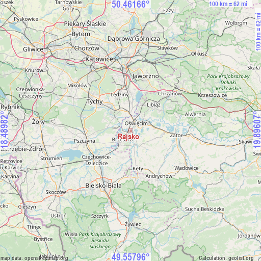
Rajsko GPS coordinates[2]
50° 0' 42.948" North, 19° 11' 34.584" East
| Map corner | latitude | longitude |
|---|---|---|
| Upper-left | 50.46166°, | 18.48982° |
| Center: | 50.01193°, | 19.19294° |
| Lower-right: | 49.55796°, | 19.89607° |
| Map W x H: | 100.5×100.5 km | = 62.4×62.4mi |
| max Lat: | 54.83135° ⇑81.9% North |
| Rajsko: | 50.01193° |
| min Lat: | ⇓18.1% South 49.21328° |
| min Long | Rajsko | max Long |
| 14.20249° | 19.19294° | 24.03723° |
| W 43.8%⇐ | ⇒56.2% E |
Elevation
Elevation of Rajsko is 239 m = 784 ft, and this is 47.6 m = 156 ft above average elevation for this country.
| Max E: |
974 m = 3196 ft | 27.2% |
| Rajsko | 239 m 784 ft | |
| Avg. | 191.4 m = 628 ft | |
Min E: |
-3 m = -10 ft | 72.8% |
See also: Poland elevation on elevation.city.
Geographical zone
Rajsko is located in North temperate zone (between Tropic of Cancer and the Arctic Circle). Distance of this North polar circle is 1840.4 km =1143.6 mi to North.| Distance of | km | miles | from Rajsko |
|---|---|---|---|
| North Pole | 4446.3 | 2762.8 | to North |
| Arctic Circle | 1840.4 | 1143.6 | to North |
| Tropic Cancer | 2954.9 | 1836.1 | to South |
| Equator | 5560.8 | 3455.3 | to South |


Nearby cities:
15 places around Rajsko: (largest is in red/bold)
• Babice
4.9 km =3 mi,  5°
5°
• Bojszowy
8.3 km =5.2 mi,  307°
307°
• Brzeszcze
4.4 km =2.7 mi,  221°
221°
• Brzezinka
3.4 km =2.1 mi,  356°
356°
• Gilowice
7.2 km =4.5 mi,  254°
254°
• Grojec
4.7 km =2.9 mi,  136°
136°
• Góra
7.3 km =4.5 mi,  240°
240°
• Harmęże
2.4 km =1.5 mi,  295°
295°
• Osiek
8.5 km =5.3 mi, 143°
• Oświęcim
2.8 km =1.7 mi,  26°
26°
• Poręba Wielka
6.5 km =4 mi,  90°
90°
• Przecieszyn
4.1 km =2.5 mi,  203°
203°
• Skidziń
3.7 km =2.3 mi,  173°
173°
• Wola
5 km =3.1 mi,  277°
277°
• Zaborze
3.6 km =2.2 mi,  72°
72°
Sources, notices
• [Note1] Compared only with cities in Poland existing in our database
• [Src1] Map data: © OpenStreetMap contributors (CC-BY-SA)
• [Src2] Other city data from geonames.org with taken over terms of usage.
• [Src3] Geographical zone / Annual Mean Temperature by Robert A. Rohde @ Wikipedia
