Zator geodata
Zator (Lesser Poland) is a seat of a third-order administrative division; located in Poland in Europe/Warsaw (GMT+2) time zone. With population of 4,779 people, there are 705 cities with bigger population in this country. Compared to other cities in Poland, 82.6% of cities are located further ↑North; 52.1% of cities are located further →East and 73.8% of cities have lower elevation than Zator. Note1


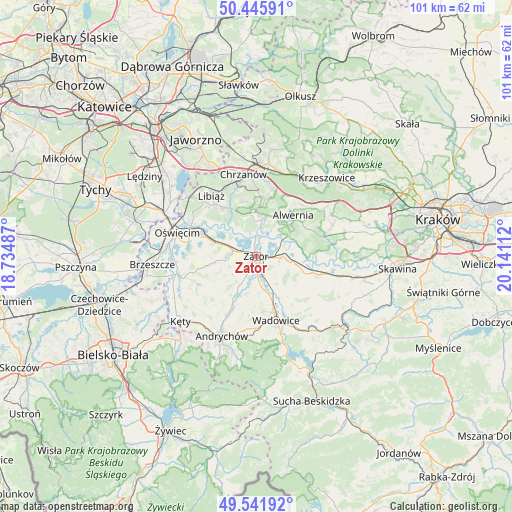
Zator GPS coordinates[2]
49° 59' 45.744" North, 19° 26' 16.764" East
| Map corner | latitude | longitude |
|---|---|---|
| Upper-left | 50.44591°, | 18.73487° |
| Center: | 49.99604°, | 19.43799° |
| Lower-right: | 49.54192°, | 20.14112° |
| Map W x H: | 100.5×100.5 km | = 62.4×62.4mi |
| max Lat: | 54.83135° ⇑82.6% North |
| Zator: | 49.99604° |
| min Lat: | ⇓17.4% South 49.21328° |
| min Long | Zator | max Long |
| 14.20249° | 19.43799° | 24.03723° |
| W 47.9%⇐ | ⇒52.1% E |
Elevation
Elevation of Zator is 242 m = 794 ft, and this is 50.6 m = 166 ft above average elevation for this country.
| Max E: |
974 m = 3196 ft | 26.2% |
| Zator | 242 m 794 ft | |
| Avg. | 191.4 m = 628 ft | |
Min E: |
-3 m = -10 ft | 73.8% |
See also: Poland elevation on elevation.city.
Geographical zone
Zator is located in North temperate zone (between Tropic of Cancer and the Arctic Circle). Distance of this North polar circle is 1842.1 km =1144.6 mi to North.| Distance of | km | miles | from Zator |
|---|---|---|---|
| North Pole | 4448 | 2763.9 | to North |
| Arctic Circle | 1842.1 | 1144.6 | to North |
| Tropic Cancer | 2953.1 | 1835 | to South |
| Equator | 5559 | 3454.2 | to South |


Nearby cities:
15 places around Zator: (largest is in red/bold)
• Babice
8.1 km =5 mi,  5°
5°
• Bachowice
5.8 km =3.6 mi,  136°
136°
• Gierałtowice
6.7 km =4.2 mi,  210°
210°
• Graboszyce
5.7 km =3.5 mi,  171°
171°
• Jankowice
5.4 km =3.4 mi,  3°
3°
• Kwaczała
8.5 km =5.3 mi,  27°
27°
• Mętków
7.7 km =4.8 mi,  324°
324°
• Okleśna
7.7 km =4.8 mi,  59°
59°
• Olszyny
6.4 km =4 mi, 9°
• Polanka Wielka
8.1 km =5 mi,  261°
261°
• Przeciszów
4.6 km =2.9 mi,  284°
284°
• Rozkochów
6.6 km =4.1 mi, 34°
• Ryczów
8.2 km =5.1 mi,  101°
101°
• Spytkowice
5.2 km =3.2 mi,  89°
89°
• Woźniki
7.5 km =4.7 mi,  149°
149°
Sources, notices
• [Note1] Compared only with cities in Poland existing in our database
• [Src1] Map data: © OpenStreetMap contributors (CC-BY-SA)
• [Src2] Other city data from geonames.org with taken over terms of usage.
• [Src3] Geographical zone / Annual Mean Temperature by Robert A. Rohde @ Wikipedia
