Przeciszów geodata
Przeciszów (Lesser Poland) is a populated place; located in Poland in Europe/Warsaw (GMT+2) time zone. With population of 3,996 people, there are 818 cities with bigger population in this country. Compared to other cities in Poland, 82.1% of cities are located further ↑North; 53.1% of cities are located further →East and 70.6% of cities have lower elevation than Przeciszów. Note1


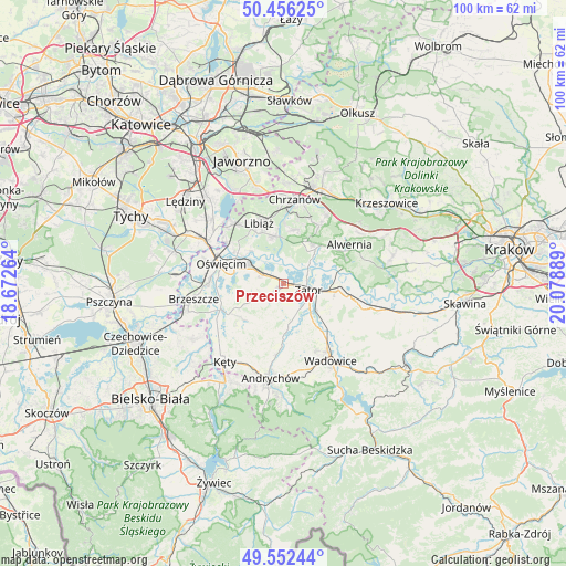
Przeciszów GPS coordinates[2]
50° 0' 23.292" North, 19° 22' 32.736" East
| Map corner | latitude | longitude |
|---|---|---|
| Upper-left | 50.45625°, | 18.67264° |
| Center: | 50.00647°, | 19.37576° |
| Lower-right: | 49.55244°, | 20.07889° |
| Map W x H: | 100.5×100.5 km | = 62.4×62.4mi |
| max Lat: | 54.83135° ⇑82.1% North |
| Przeciszów: | 50.00647° |
| min Lat: | ⇓17.9% South 49.21328° |
| min Long | Przeciszów | max Long |
| 14.20249° | 19.37576° | 24.03723° |
| W 46.9%⇐ | ⇒53.1% E |
Elevation
Elevation of Przeciszów is 231 m = 758 ft, and this is 39.6 m = 130 ft above average elevation for this country.
| Max E: |
974 m = 3196 ft | 29.4% |
| Przeciszów | 231 m 758 ft | |
| Avg. | 191.4 m = 628 ft | |
Min E: |
-3 m = -10 ft | 70.6% |
See also: Poland elevation on elevation.city.
Geographical zone
Przeciszów is located in North temperate zone (between Tropic of Cancer and the Arctic Circle). Distance of this North polar circle is 1841 km =1143.9 mi to North.| Distance of | km | miles | from Przeciszów |
|---|---|---|---|
| North Pole | 4446.9 | 2763.2 | to North |
| Arctic Circle | 1841 | 1143.9 | to North |
| Tropic Cancer | 2954.3 | 1835.7 | to South |
| Equator | 5560.2 | 3454.9 | to South |


Nearby cities:
15 places around Przeciszów: (largest is in red/bold)
• Babice
8.7 km =5.4 mi,  37°
37°
• Gierałtowice
7 km =4.3 mi,  171°
171°
• Graboszyce
8.6 km =5.3 mi,  142°
142°
• Jankowice
6.3 km =3.9 mi,  48°
48°
• Mętków
5.1 km =3.2 mi,  359°
359°
• Olszyny
7.5 km =4.7 mi, 46°
• Polanka Wielka
4.3 km =2.7 mi,  236°
236°
• Poręba Wielka
6.6 km =4.1 mi,  274°
274°
• Rozkochów
9.2 km =5.7 mi,  62°
62°
• Spytkowice
9.7 km =6 mi,  96°
96°
• Włosienica
4.4 km =2.7 mi,  287°
287°
• Zaborze
9.8 km =6.1 mi,  279°
279°
• Zagórze
10 km =6.2 mi,  11°
11°
• Zator
4.6 km =2.9 mi, 104°
• Żarki
8.6 km =5.3 mi,  348°
348°
Sources, notices
• [Note1] Compared only with cities in Poland existing in our database
• [Src1] Map data: © OpenStreetMap contributors (CC-BY-SA)
• [Src2] Other city data from geonames.org with taken over terms of usage.
• [Src3] Geographical zone / Annual Mean Temperature by Robert A. Rohde @ Wikipedia
