Przecieszyn geodata
Przecieszyn (Lesser Poland) is a populated place; located in Poland in Europe/Warsaw (GMT+2) time zone. With population of 1,157 people, there are 2251 cities with bigger population in this country. Compared to other cities in Poland, 84% of cities are located further ↑North; 56.7% of cities are located further →East and 76.5% of cities have lower elevation than Przecieszyn. Note1


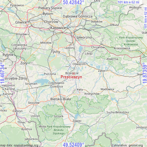
Przecieszyn GPS coordinates[2]
49° 58' 42.168" North, 19° 10' 13.656" East
| Map corner | latitude | longitude |
|---|---|---|
| Upper-left | 50.42842°, | 18.46734° |
| Center: | 49.97838°, | 19.17046° |
| Lower-right: | 49.52409°, | 19.87359° |
| Map W x H: | 100.6×100.6 km | = 62.5×62.5mi |
| max Lat: | 54.83135° ⇑84% North |
| Przecieszyn: | 49.97838° |
| min Lat: | ⇓16% South 49.21328° |
| min Long | Przecieszyn | max Long |
| 14.20249° | 19.17046° | 24.03723° |
| W 43.3%⇐ | ⇒56.7% E |
Elevation
Elevation of Przecieszyn is 252 m = 827 ft, and this is 60.6 m = 199 ft above average elevation for this country.
| Max E: |
974 m = 3196 ft | 23.5% |
| Przecieszyn | 252 m 827 ft | |
| Avg. | 191.4 m = 628 ft | |
Min E: |
-3 m = -10 ft | 76.5% |
See also: Poland elevation on elevation.city.
Geographical zone
Przecieszyn is located in North temperate zone (between Tropic of Cancer and the Arctic Circle). Distance of this North polar circle is 1844.1 km =1145.9 mi to North.| Distance of | km | miles | from Przecieszyn |
|---|---|---|---|
| North Pole | 4450 | 2765.1 | to North |
| Arctic Circle | 1844.1 | 1145.9 | to North |
| Tropic Cancer | 2951.2 | 1833.8 | to South |
| Equator | 5557.1 | 3453 | to South |


Nearby cities:
15 places around Przecieszyn: (largest is in red/bold)
• Brzeszcze
1.4 km =0.9 mi,  286°
286°
• Brzezinka
7.3 km =4.5 mi,  11°
11°
• Frydek
7.3 km =4.5 mi, 285°
• Gilowice
5.6 km =3.5 mi, 289°
• Grojec
4.8 km =3 mi,  85°
85°
• Góra
4.7 km =2.9 mi,  271°
271°
• Harmęże
4.8 km =3 mi,  352°
352°
• Malec
8.3 km =5.2 mi,  139°
139°
• Osiek
7.4 km =4.6 mi,  114°
114°
• Oświęcim
6.8 km =4.2 mi,  24°
24°
• Rajsko
4.1 km =2.5 mi, 23°
• Skidziń
2 km =1.2 mi, 87°
• Wilamowice
6.9 km =4.3 mi,  190°
190°
• Wola
5.5 km =3.4 mi,  322°
322°
• Zaborze
7 km =4.3 mi,  46°
46°
Sources, notices
• [Note1] Compared only with cities in Poland existing in our database
• [Src1] Map data: © OpenStreetMap contributors (CC-BY-SA)
• [Src2] Other city data from geonames.org with taken over terms of usage.
• [Src3] Geographical zone / Annual Mean Temperature by Robert A. Rohde @ Wikipedia
