Śrem geodata
Śrem (Greater Poland) is a seat of a second-order administrative division; located in Poland in Europe/Warsaw (GMT+2) time zone. With population of 30,404 people, there are 162 cities with bigger population in this country. Compared to other cities in Poland, 67.6% of cities are located further ↓South; 84.5% of cities are located further →East and 88.9% of cities have higher elevation than Śrem. Note1


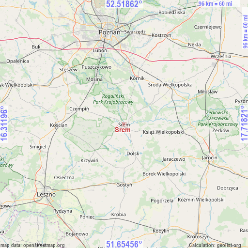
Śrem GPS coordinates[2]
52° 5' 19.248" North, 17° 0' 54.288" East
| Map corner | latitude | longitude |
|---|---|---|
| Upper-left | 52.51862°, | 16.31196° |
| Center: | 52.08868°, | 17.01508° |
| Lower-right: | 51.65456°, | 17.71821° |
| Map W x H: | 96.1×96.1 km | = 59.7×59.7mi |
| max Lat: | 54.83135° ⇑32.4% North |
| Śrem: | 52.08868° |
| min Lat: | ⇓67.6% South 49.21328° |
| min Long | Śrem | max Long |
| 14.20249° | 17.01508° | 24.03723° |
| W 15.5%⇐ | ⇒84.5% E |
Elevation
Elevation of Śrem is 79 m = 259 ft, and this is 112.4 m = 369 ft below average elevation for this country.
| Max E: |
974 m = 3196 ft | 88.9% |
| Avg. | 191.4 m = 628 ft | |
| Śrem | 79 m = 259 ft | |
Min E: |
-3 m = -10 ft | 11.1% |
See also: Poland elevation on elevation.city.
Geographical zone
Śrem is located in North temperate zone (between Tropic of Cancer and the Arctic Circle). Distance of this North polar circle is 1609.5 km =1000.1 mi to North.| Distance of | km | miles | from Śrem |
|---|---|---|---|
| North Pole | 4215.3 | 2619.3 | to North |
| Arctic Circle | 1609.5 | 1000.1 | to North |
| Tropic Cancer | 3185.8 | 1979.6 | to South |
| Equator | 5791.7 | 3598.8 | to South |


Nearby cities:
15 places around Śrem: (largest is in red/bold)
• Brodnica
10.3 km =6.4 mi,  304°
304°
• Czempiń
18.2 km =11.3 mi,  289°
289°
• Dolsk
12.3 km =7.6 mi,  164°
164°
• Krosno
19.5 km =12.1 mi,  320°
320°
• Krzywiń
19.3 km =12 mi,  223°
223°
• Książ Wielkopolski
15.6 km =9.7 mi,  101°
101°
• Kórnik
18.4 km =11.4 mi,  16°
16°
• Lubiń
15.9 km =9.9 mi,  210°
210°
• Mosina
20.9 km =13 mi,  326°
326°
• Nochowo
3.1 km =1.9 mi,  235°
235°
• Pecna
18.1 km =11.2 mi,  305°
305°
• Rogalin
17.1 km =10.6 mi,  342°
342°
• Rogalinek
19.5 km =12.1 mi, 336°
• Słupia Wiełka
20 km =12.4 mi,  44°
44°
• Zaniemyśl
12.5 km =7.8 mi,  53°
53°
Sources, notices
• [Note1] Compared only with cities in Poland existing in our database
• [Src1] Map data: © OpenStreetMap contributors (CC-BY-SA)
• [Src2] Other city data from geonames.org with taken over terms of usage.
• [Src3] Geographical zone / Annual Mean Temperature by Robert A. Rohde @ Wikipedia
