Zaniemyśl geodata
Zaniemyśl (Greater Poland) is a seat of a third-order administrative division; located in Poland in Europe/Warsaw (GMT+2) time zone. With population of 2,200 people, there are 1362 cities with bigger population in this country. Compared to other cities in Poland, 69.1% of cities are located further ↓South; 82.6% of cities are located further →East and 90.2% of cities have higher elevation than Zaniemyśl. Note1


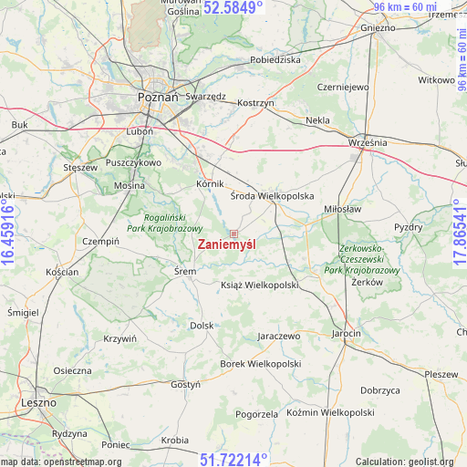
Zaniemyśl GPS coordinates[2]
52° 9' 20.196" North, 17° 9' 44.208" East
| Map corner | latitude | longitude |
|---|---|---|
| Upper-left | 52.5849°, | 16.45916° |
| Center: | 52.15561°, | 17.16228° |
| Lower-right: | 51.72214°, | 17.86541° |
| Map W x H: | 95.9×95.9 km | = 59.6×59.6mi |
| max Lat: | 54.83135° ⇑30.9% North |
| Zaniemyśl: | 52.15561° |
| min Lat: | ⇓69.1% South 49.21328° |
| min Long | Zaniemyśl | max Long |
| 14.20249° | 17.16228° | 24.03723° |
| W 17.4%⇐ | ⇒82.6% E |
Elevation
Elevation of Zaniemyśl is 75 m = 246 ft, and this is 116.4 m = 382 ft below average elevation for this country.
| Max E: |
974 m = 3196 ft | 90.2% |
| Avg. | 191.4 m = 628 ft | |
| Zaniemyśl | 75 m = 246 ft | |
Min E: |
-3 m = -10 ft | 9.8% |
See also: Poland elevation on elevation.city.
Geographical zone
Zaniemyśl is located in North temperate zone (between Tropic of Cancer and the Arctic Circle). Distance of this North polar circle is 1602 km =995.4 mi to North.| Distance of | km | miles | from Zaniemyśl |
|---|---|---|---|
| North Pole | 4207.9 | 2614.7 | to North |
| Arctic Circle | 1602 | 995.4 | to North |
| Tropic Cancer | 3193.2 | 1984.2 | to South |
| Equator | 5799.2 | 3603.5 | to South |


Nearby cities:
15 places around Zaniemyśl: (largest is in red/bold)
• Brodnica
18.6 km =11.6 mi,  265°
265°
• Dolsk
20.5 km =12.7 mi,  199°
199°
• Dominowo
20.1 km =12.5 mi,  41°
41°
• Gądki
19.1 km =11.9 mi,  335°
335°
• Kleszczewo
19.8 km =12.3 mi,  1°
1°
• Krzykosy
15.3 km =9.5 mi,  109°
109°
• Książ Wielkopolski
11.7 km =7.3 mi,  153°
153°
• Kórnik
11.4 km =7.1 mi,  334°
334°
• Nochowo
15.6 km =9.7 mi,  233°
233°
• Nowe Miasto nad Wartą
18.5 km =11.5 mi, 113°
• Rogalin
17.7 km =11 mi,  300°
300°
• Solec
12.6 km =7.8 mi,  115°
115°
• Słupia Wiełka
8 km =5 mi,  29°
29°
• Śrem
12.5 km =7.8 mi, 233°
• Środa Wielkopolska
11.2 km =7 mi, 43°
Sources, notices
• [Note1] Compared only with cities in Poland existing in our database
• [Src1] Map data: © OpenStreetMap contributors (CC-BY-SA)
• [Src2] Other city data from geonames.org with taken over terms of usage.
• [Src3] Geographical zone / Annual Mean Temperature by Robert A. Rohde @ Wikipedia
