Nochowo geodata
Nochowo (Greater Poland) is a populated place; located in Poland in Europe/Warsaw (GMT+2) time zone. With population of 870 people, there are 2725 cities with bigger population in this country. Compared to other cities in Poland, 67% of cities are located further ↓South; 85.1% of cities are located further →East and 88.9% of cities have higher elevation than Nochowo. Note1


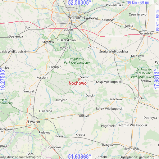
Nochowo GPS coordinates[2]
52° 4' 22.656" North, 16° 58' 41.412" East
| Map corner | latitude | longitude |
|---|---|---|
| Upper-left | 52.50305°, | 16.27505° |
| Center: | 52.07296°, | 16.97817° |
| Lower-right: | 51.63868°, | 17.6813° |
| Map W x H: | 96.1×96.1 km | = 59.7×59.7mi |
| max Lat: | 54.83135° ⇑33% North |
| Nochowo: | 52.07296° |
| min Lat: | ⇓67% South 49.21328° |
| min Long | Nochowo | max Long |
| 14.20249° | 16.97817° | 24.03723° |
| W 14.9%⇐ | ⇒85.1% E |
Elevation
Elevation of Nochowo is 79 m = 259 ft, and this is 112.4 m = 369 ft below average elevation for this country.
| Max E: |
974 m = 3196 ft | 88.9% |
| Avg. | 191.4 m = 628 ft | |
| Nochowo | 79 m = 259 ft | |
Min E: |
-3 m = -10 ft | 11.1% |
See also: Poland elevation on elevation.city.
Geographical zone
Nochowo is located in North temperate zone (between Tropic of Cancer and the Arctic Circle). Distance of this North polar circle is 1611.2 km =1001.2 mi to North.| Distance of | km | miles | from Nochowo |
|---|---|---|---|
| North Pole | 4217.1 | 2620.4 | to North |
| Arctic Circle | 1611.2 | 1001.2 | to North |
| Tropic Cancer | 3184.1 | 1978.5 | to South |
| Equator | 5790 | 3597.7 | to South |


Nearby cities:
15 places around Nochowo: (largest is in red/bold)
• Brodnica
9.6 km =6 mi,  321°
321°
• Czempiń
16.6 km =10.3 mi,  298°
298°
• Dolsk
11.7 km =7.3 mi,  150°
150°
• Krosinko
21.1 km =13.1 mi,  327°
327°
• Krosno
19.5 km =12.1 mi, 329°
• Krzywiń
16.3 km =10.1 mi,  221°
221°
• Książ Wielkopolski
17.9 km =11.1 mi,  94°
94°
• Kórnik
20.9 km =13 mi,  21°
21°
• Lubiń
13.2 km =8.2 mi,  204°
204°
• Mosina
21.2 km =13.2 mi,  335°
335°
• Pecna
17.3 km =10.7 mi, 315°
• Rogalin
18.2 km =11.3 mi,  351°
351°
• Rogalinek
20.3 km =12.6 mi, 344°
• Zaniemyśl
15.6 km =9.7 mi,  53°
53°
• Śrem
3.1 km =1.9 mi,  55°
55°
Sources, notices
• [Note1] Compared only with cities in Poland existing in our database
• [Src1] Map data: © OpenStreetMap contributors (CC-BY-SA)
• [Src2] Other city data from geonames.org with taken over terms of usage.
• [Src3] Geographical zone / Annual Mean Temperature by Robert A. Rohde @ Wikipedia
