Soblówka geodata
Soblówka (Silesia) is a populated place; located in Poland in Europe/Warsaw (GMT+2) time zone. With population of 687 people, there are 3095 cities with bigger population in this country. Compared to other cities in Poland, 99.3% of cities are located further ↑North; 57.3% of cities are located further →East and 99.4% of cities have lower elevation than Soblówka. Note1


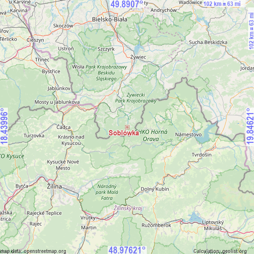
Soblówka GPS coordinates[2]
49° 26' 8.124" North, 19° 8' 35.088" East
| Map corner | latitude | longitude |
|---|---|---|
| Upper-left | 49.8907°, | 18.43996° |
| Center: | 49.43559°, | 19.14308° |
| Lower-right: | 48.97621°, | 19.84621° |
| Map W x H: | 101.7×101.7 km | = 63.2×63.2mi |
| max Lat: | 54.83135° ⇑99.3% North |
| Soblówka: | 49.43559° |
| min Lat: | ⇓0.7% South 49.21328° |
| min Long | Soblówka | max Long |
| 14.20249° | 19.14308° | 24.03723° |
| W 42.7%⇐ | ⇒57.3% E |
Elevation
Elevation of Soblówka is 666 m = 2185 ft, and this is 474.6 m = 1557 ft above average elevation for this country.
| Max E: |
974 m = 3196 ft | 0.59999999999999% |
| Soblówka | 666 m 2185 ft | |
| Avg. | 191.4 m = 628 ft | |
Min E: |
-3 m = -10 ft | 99.4% |
See also: Poland elevation on elevation.city.
Geographical zone
Soblówka is located in North temperate zone (between Tropic of Cancer and the Arctic Circle). Distance of this North polar circle is 1904.5 km =1183.4 mi to North.| Distance of | km | miles | from Soblówka |
|---|---|---|---|
| North Pole | 4510.3 | 2802.6 | to North |
| Arctic Circle | 1904.5 | 1183.4 | to North |
| Tropic Cancer | 2890.8 | 1796.3 | to South |
| Equator | 5496.7 | 3415.5 | to South |


Nearby cities:
15 places around Soblówka: (largest is in red/bold)
• Cisiec
17.6 km =10.9 mi,  351°
351°
• Cięcina
18.5 km =11.5 mi,  359°
359°
• Glinka
3.3 km =2.1 mi,  24°
24°
• Kamesznica
16.8 km =10.4 mi,  328°
328°
• Koniaków
19 km =11.8 mi,  312°
312°
• Laliki
14.8 km =9.2 mi,  317°
317°
• Milówka
13.8 km =8.6 mi,  344°
344°
• Rajcza
8.5 km =5.3 mi, 345°
• Rycerka Dolna
7.5 km =4.7 mi, 308°
• Rycerka Górna
9.2 km =5.7 mi,  276°
276°
• Sopotnia Wielka
17.9 km =11.1 mi,  34°
34°
• Sól
9.3 km =5.8 mi, 308°
• Ujsoły
5.3 km =3.3 mi, 356°
• Zwardoń
14.2 km =8.8 mi,  302°
302°
• Żabnica
16.2 km =10.1 mi,  3°
3°
Sources, notices
• [Note1] Compared only with cities in Poland existing in our database
• [Src1] Map data: © OpenStreetMap contributors (CC-BY-SA)
• [Src2] Other city data from geonames.org with taken over terms of usage.
• [Src3] Geographical zone / Annual Mean Temperature by Robert A. Rohde @ Wikipedia
