Radziszów geodata
Radziszów (Lesser Poland) is a populated place; located in Poland in Europe/Warsaw (GMT+2) time zone. With population of 2,800 people, there are 1120 cities with bigger population in this country. Compared to other cities in Poland, 86.2% of cities are located further ↑North; 55.1% of cities are located further ←West and 67.1% of cities have lower elevation than Radziszów. Note1


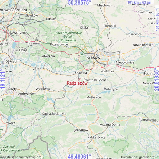
Radziszów GPS coordinates[2]
49° 56' 7.116" North, 19° 48' 54.792" East
| Map corner | latitude | longitude |
|---|---|---|
| Upper-left | 50.38575°, | 19.1121° |
| Center: | 49.93531°, | 19.81522° |
| Lower-right: | 49.48061°, | 20.51835° |
| Map W x H: | 100.6×100.6 km | = 62.5×62.5mi |
| max Lat: | 54.83135° ⇑86.2% North |
| Radziszów: | 49.93531° |
| min Lat: | ⇓13.8% South 49.21328° |
| min Long | Radziszów | max Long |
| 14.20249° | 19.81522° | 24.03723° |
| W 55.1%⇐ | ⇒44.9% E |
Elevation
Elevation of Radziszów is 220 m = 722 ft, and this is 28.6 m = 94 ft above average elevation for this country.
| Max E: |
974 m = 3196 ft | 32.9% |
| Radziszów | 220 m 722 ft | |
| Avg. | 191.4 m = 628 ft | |
Min E: |
-3 m = -10 ft | 67.1% |
See also: Poland elevation on elevation.city.
Geographical zone
Radziszów is located in North temperate zone (between Tropic of Cancer and the Arctic Circle). Distance of this North polar circle is 1848.9 km =1148.9 mi to North.| Distance of | km | miles | from Radziszów |
|---|---|---|---|
| North Pole | 4454.8 | 2768.1 | to North |
| Arctic Circle | 1848.9 | 1148.9 | to North |
| Tropic Cancer | 2946.4 | 1830.8 | to South |
| Equator | 5552.3 | 3450 | to South |


Nearby cities:
15 places around Radziszów: (largest is in red/bold)
• Biertowice
7.2 km =4.5 mi,  192°
192°
• Borek Szlachecki
4.3 km =2.7 mi,  319°
319°
• Buków
2.5 km =1.6 mi,  61°
61°
• Głogoczów
6.2 km =3.9 mi,  137°
137°
• Kopanka
5.6 km =3.5 mi,  343°
343°
• Krzywaczka
4.8 km =3 mi,  165°
165°
• Krzęcin
5.3 km =3.3 mi,  279°
279°
• Leńcze
7 km =4.3 mi,  234°
234°
• Libertów
7 km =4.3 mi,  54°
54°
• Mogilany
5.3 km =3.3 mi,  85°
85°
• Ochodza
6.2 km =3.9 mi,  303°
303°
• Rzozów
2.5 km =1.6 mi,  327°
327°
• Sidzina
7.2 km =4.5 mi,  36°
36°
• Skawina
4.5 km =2.8 mi,  12°
12°
• Wola Radziszowska
3.8 km =2.4 mi,  210°
210°
Sources, notices
• [Note1] Compared only with cities in Poland existing in our database
• [Src1] Map data: © OpenStreetMap contributors (CC-BY-SA)
• [Src2] Other city data from geonames.org with taken over terms of usage.
• [Src3] Geographical zone / Annual Mean Temperature by Robert A. Rohde @ Wikipedia
