Krzęcin geodata
Krzęcin (Lesser Poland) is a populated place; located in Poland in Europe/Warsaw (GMT+2) time zone. With population of 1,400 people, there are 1959 cities with bigger population in this country. Compared to other cities in Poland, 86% of cities are located further ↑North; 53.6% of cities are located further ←West and 80.3% of cities have lower elevation than Krzęcin. Note1


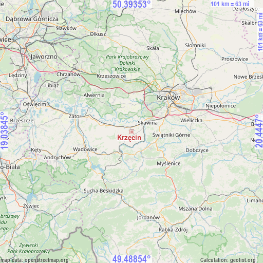
Krzęcin GPS coordinates[2]
49° 56' 35.376" North, 19° 44' 29.652" East
| Map corner | latitude | longitude |
|---|---|---|
| Upper-left | 50.39353°, | 19.03845° |
| Center: | 49.94316°, | 19.74157° |
| Lower-right: | 49.48854°, | 20.4447° |
| Map W x H: | 100.6×100.6 km | = 62.5×62.5mi |
| max Lat: | 54.83135° ⇑86% North |
| Krzęcin: | 49.94316° |
| min Lat: | ⇓14% South 49.21328° |
| min Long | Krzęcin | max Long |
| 14.20249° | 19.74157° | 24.03723° |
| W 53.6%⇐ | ⇒46.4% E |
Elevation
Elevation of Krzęcin is 267 m = 876 ft, and this is 75.6 m = 248 ft above average elevation for this country.
| Max E: |
974 m = 3196 ft | 19.7% |
| Krzęcin | 267 m 876 ft | |
| Avg. | 191.4 m = 628 ft | |
Min E: |
-3 m = -10 ft | 80.3% |
See also: Poland elevation on elevation.city.
Geographical zone
Krzęcin is located in North temperate zone (between Tropic of Cancer and the Arctic Circle). Distance of this North polar circle is 1848 km =1148.3 mi to North.| Distance of | km | miles | from Krzęcin |
|---|---|---|---|
| North Pole | 4453.9 | 2767.5 | to North |
| Arctic Circle | 1848 | 1148.3 | to North |
| Tropic Cancer | 2947.2 | 1831.3 | to South |
| Equator | 5553.2 | 3450.6 | to South |


Nearby cities:
15 places around Krzęcin: (largest is in red/bold)
• Borek Szlachecki
3.4 km =2.1 mi,  45°
45°
• Bęczyn
5.9 km =3.7 mi,  261°
261°
• Facimiech
3.1 km =1.9 mi,  329°
329°
• Jeziorzany
6.2 km =3.9 mi,  23°
23°
• Kopanka
5.8 km =3.6 mi,  39°
39°
• Leńcze
4.9 km =3 mi,  185°
185°
• Ochodza
2.5 km =1.6 mi,  2°
2°
• Paszkówka
4.6 km =2.9 mi, 264°
• Pozowice
4.6 km =2.9 mi,  317°
317°
• Przytkowice
4.9 km =3 mi,  234°
234°
• Radziszów
5.3 km =3.3 mi,  99°
99°
• Rzozów
4.1 km =2.5 mi,  73°
73°
• Sosnowice
1.9 km =1.2 mi, 259°
• Wola Radziszowska
5.4 km =3.4 mi,  141°
141°
• Wołowice
5.2 km =3.2 mi,  347°
347°
Sources, notices
• [Note1] Compared only with cities in Poland existing in our database
• [Src1] Map data: © OpenStreetMap contributors (CC-BY-SA)
• [Src2] Other city data from geonames.org with taken over terms of usage.
• [Src3] Geographical zone / Annual Mean Temperature by Robert A. Rohde @ Wikipedia
