Rząska geodata
Rząska (Lesser Poland) is a populated place; located in Poland in Europe/Warsaw (GMT+2) time zone. With population of 2,082 people, there are 1436 cities with bigger population in this country. Compared to other cities in Poland, 78.1% of cities are located further ↑North; 55.8% of cities are located further ←West and 74.6% of cities have lower elevation than Rząska. Note1


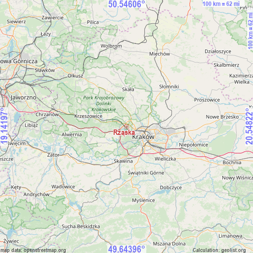
Rząska GPS coordinates[2]
50° 5' 49.668" North, 19° 50' 42.324" East
| Map corner | latitude | longitude |
|---|---|---|
| Upper-left | 50.54606°, | 19.14197° |
| Center: | 50.09713°, | 19.84509° |
| Lower-right: | 49.64396°, | 20.54822° |
| Map W x H: | 100.3×100.3 km | = 62.3×62.3mi |
| max Lat: | 54.83135° ⇑78.1% North |
| Rząska: | 50.09713° |
| min Lat: | ⇓21.9% South 49.21328° |
| min Long | Rząska | max Long |
| 14.20249° | 19.84509° | 24.03723° |
| W 55.8%⇐ | ⇒44.2% E |
Elevation
Elevation of Rząska is 245 m = 804 ft, and this is 53.6 m = 176 ft above average elevation for this country.
| Max E: |
974 m = 3196 ft | 25.4% |
| Rząska | 245 m 804 ft | |
| Avg. | 191.4 m = 628 ft | |
Min E: |
-3 m = -10 ft | 74.6% |
See also: Poland elevation on elevation.city.
Geographical zone
Rząska is located in North temperate zone (between Tropic of Cancer and the Arctic Circle). Distance of this North polar circle is 1830.9 km =1137.7 mi to North.| Distance of | km | miles | from Rząska |
|---|---|---|---|
| North Pole | 4436.8 | 2756.9 | to North |
| Arctic Circle | 1830.9 | 1137.7 | to North |
| Tropic Cancer | 2964.4 | 1842 | to South |
| Equator | 5570.3 | 3461.2 | to South |


Nearby cities:
15 places around Rząska: (largest is in red/bold)
• Aleksandrowice
6 km =3.7 mi,  253°
253°
• Balice
3.7 km =2.3 mi, 254°
• Bolechowice
6.8 km =4.2 mi,  326°
326°
• Brzezie
3.3 km =2.1 mi, 331°
• Cholerzyn
7.1 km =4.4 mi,  234°
234°
• Giebułtów
5.9 km =3.7 mi,  23°
23°
• Kryspinów
6.8 km =4.2 mi,  209°
209°
• Modlnica
3.9 km =2.4 mi, 21°
• Modlniczka
2.4 km =1.5 mi, 17°
• Morawica
7 km =4.3 mi, 249°
• Szczyglice
1.3 km =0.8 mi,  243°
243°
• Tomaszowice
4.3 km =2.7 mi,  1°
1°
• Wielka Wieś
6.7 km =4.2 mi,  359°
359°
• Zabierzów
3.9 km =2.4 mi,  299°
299°
• Zielonki
6.1 km =3.8 mi,  64°
64°
Sources, notices
• [Note1] Compared only with cities in Poland existing in our database
• [Src1] Map data: © OpenStreetMap contributors (CC-BY-SA)
• [Src2] Other city data from geonames.org with taken over terms of usage.
• [Src3] Geographical zone / Annual Mean Temperature by Robert A. Rohde @ Wikipedia
