Zielonki geodata
Zielonki (Lesser Poland) is a populated place; located in Poland in Europe/Warsaw (GMT+2) time zone. With population of 2,936 people, there are 1076 cities with bigger population in this country. Compared to other cities in Poland, 77.2% of cities are located further ↑North; 57% of cities are located further ←West and 70.6% of cities have lower elevation than Zielonki. Note1


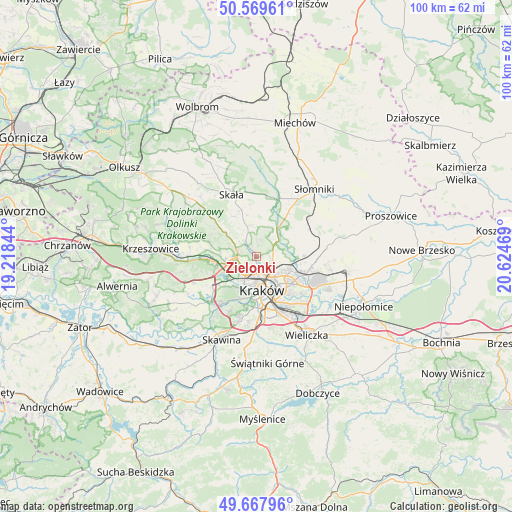
Zielonki GPS coordinates[2]
50° 7' 15.276" North, 19° 55' 17.616" East
| Map corner | latitude | longitude |
|---|---|---|
| Upper-left | 50.56961°, | 19.21844° |
| Center: | 50.12091°, | 19.92156° |
| Lower-right: | 49.66796°, | 20.62469° |
| Map W x H: | 100.3×100.3 km | = 62.3×62.3mi |
| max Lat: | 54.83135° ⇑77.2% North |
| Zielonki: | 50.12091° |
| min Lat: | ⇓22.8% South 49.21328° |
| min Long | Zielonki | max Long |
| 14.20249° | 19.92156° | 24.03723° |
| W 57%⇐ | ⇒43% E |
Elevation
Elevation of Zielonki is 231 m = 758 ft, and this is 39.6 m = 130 ft above average elevation for this country.
| Max E: |
974 m = 3196 ft | 29.4% |
| Zielonki | 231 m 758 ft | |
| Avg. | 191.4 m = 628 ft | |
Min E: |
-3 m = -10 ft | 70.6% |
See also: Poland elevation on elevation.city.
Geographical zone
Zielonki is located in North temperate zone (between Tropic of Cancer and the Arctic Circle). Distance of this North polar circle is 1828.3 km =1136.1 mi to North.| Distance of | km | miles | from Zielonki |
|---|---|---|---|
| North Pole | 4434.1 | 2755.2 | to North |
| Arctic Circle | 1828.3 | 1136.1 | to North |
| Tropic Cancer | 2967 | 1843.6 | to South |
| Equator | 5572.9 | 3462.8 | to South |


Nearby cities:
15 places around Zielonki: (largest is in red/bold)
• Balice
9.8 km =6.1 mi,  247°
247°
• Bolechowice
9.7 km =6 mi,  288°
288°
• Brzezie
7 km =4.3 mi,  271°
271°
• Giebułtów
4.1 km =2.5 mi,  311°
311°
• Kraków
6.7 km =4.2 mi,  170°
170°
• Masłomiąca
7.3 km =4.5 mi,  51°
51°
• Michałowice
6 km =3.7 mi,  44°
44°
• Modlnica
4.2 km =2.6 mi,  283°
283°
• Modlniczka
4.7 km =2.9 mi, 265°
• Rząska
6.1 km =3.8 mi,  244°
244°
• Szczyglice
7.4 km =4.6 mi, 244°
• Tomaszowice
5.6 km =3.5 mi, 287°
• Wielka Wieś
6.8 km =4.2 mi, 305°
• Zabierzów
8.8 km =5.5 mi, 265°
• Zelków
10 km =6.2 mi,  295°
295°
Sources, notices
• [Note1] Compared only with cities in Poland existing in our database
• [Src1] Map data: © OpenStreetMap contributors (CC-BY-SA)
• [Src2] Other city data from geonames.org with taken over terms of usage.
• [Src3] Geographical zone / Annual Mean Temperature by Robert A. Rohde @ Wikipedia
