Rusocin geodata
Rusocin (Pomerania) is a populated place; located in Poland in Europe/Warsaw (GMT+2) time zone. With population of 980 people, there are 2532 cities with bigger population in this country. Compared to other cities in Poland, 96.7% of cities are located further ↓South; 66.1% of cities are located further →East and 97.2% of cities have higher elevation than Rusocin. Note1


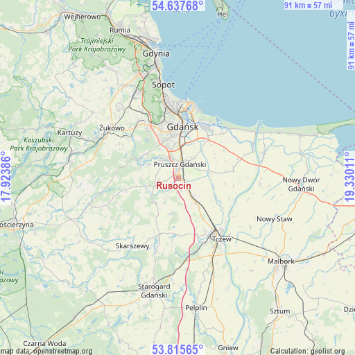
Rusocin GPS coordinates[2]
54° 13' 43.356" North, 18° 37' 37.128" East
| Map corner | latitude | longitude |
|---|---|---|
| Upper-left | 54.63768°, | 17.92386° |
| Center: | 54.22871°, | 18.62698° |
| Lower-right: | 53.81565°, | 19.33011° |
| Map W x H: | 91.4×91.4 km | = 56.8×56.8mi |
| max Lat: | 54.83135° ⇑3.3% North |
| Rusocin: | 54.22871° |
| min Lat: | ⇓96.7% South 49.21328° |
| min Long | Rusocin | max Long |
| 14.20249° | 18.62698° | 24.03723° |
| W 33.9%⇐ | ⇒66.1% E |
Elevation
Elevation of Rusocin is 20 m = 66 ft, and this is 171.4 m = 562 ft below average elevation for this country.
| Max E: |
974 m = 3196 ft | 97.2% |
| Avg. | 191.4 m = 628 ft | |
| Rusocin | 20 m = 66 ft | |
Min E: |
-3 m = -10 ft | 2.8% |
See also: Poland elevation on elevation.city.
Geographical zone
Rusocin is located in North temperate zone (between Tropic of Cancer and the Arctic Circle). Distance of this North polar circle is 1371.5 km =852.2 mi to North.| Distance of | km | miles | from Rusocin |
|---|---|---|---|
| North Pole | 3977.4 | 2471.4 | to North |
| Arctic Circle | 1371.5 | 852.2 | to North |
| Tropic Cancer | 3423.7 | 2127.4 | to South |
| Equator | 6029.7 | 3746.7 | to South |


Nearby cities:
15 places around Rusocin: (largest is in red/bold)
• Borkowo Łostowickie
8.1 km =5 mi,  345°
345°
• Cieplewo
1.8 km =1.1 mi,  69°
69°
• Juszkowo
3.5 km =2.2 mi,  332°
332°
• Kolbudy
11.4 km =7.1 mi,  293°
293°
• Kowale
10 km =6.2 mi, 334°
• Lublewo Gdańskie
10.1 km =6.3 mi,  307°
307°
• Pruszcz Gdański
3.8 km =2.4 mi,  9°
9°
• Pręgowo
10 km =6.2 mi, 286°
• Pszczółki
7.7 km =4.8 mi,  143°
143°
• Rokitnica
6.3 km =3.9 mi,  36°
36°
• Rotmanka
5.3 km =3.3 mi,  343°
343°
• Straszyn
5.7 km =3.5 mi, 328°
• Suchy Dąb
9.4 km =5.8 mi,  104°
104°
• Trąbki Wielkie
8.6 km =5.3 mi,  221°
221°
• Łęgowo
1.1 km =0.7 mi, 103°
Sources, notices
• [Note1] Compared only with cities in Poland existing in our database
• [Src1] Map data: © OpenStreetMap contributors (CC-BY-SA)
• [Src2] Other city data from geonames.org with taken over terms of usage.
• [Src3] Geographical zone / Annual Mean Temperature by Robert A. Rohde @ Wikipedia
