Suchy Dąb geodata
Suchy Dąb (Pomerania) is a seat of a third-order administrative division; located in Poland in Europe/Warsaw (GMT+2) time zone. With population of 832 people, there are 2793 cities with bigger population in this country. Compared to other cities in Poland, 96.4% of cities are located further ↓South; 63.9% of cities are located further →East and 99.8% of cities have higher elevation than Suchy Dąb. Note1


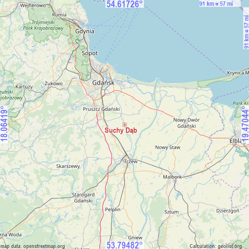
Suchy Dąb GPS coordinates[2]
54° 12' 29.124" North, 18° 46' 2.316" East
| Map corner | latitude | longitude |
|---|---|---|
| Upper-left | 54.61726°, | 18.06419° |
| Center: | 54.20809°, | 18.76731° |
| Lower-right: | 53.79482°, | 19.47044° |
| Map W x H: | 91.4×91.4 km | = 56.8×56.8mi |
| max Lat: | 54.83135° ⇑3.6% North |
| Suchy Dąb: | 54.20809° |
| min Lat: | ⇓96.4% South 49.21328° |
| min Long | Suchy Dąb | max Long |
| 14.20249° | 18.76731° | 24.03723° |
| W 36.1%⇐ | ⇒63.9% E |
Elevation
Elevation of Suchy Dąb is 1 m = 3 ft, and this is 190.4 m = 625 ft below average elevation for this country.
| Max E: |
974 m = 3196 ft | 99.8% |
| Avg. | 191.4 m = 628 ft | |
| Suchy Dąb | 1 m = 3 ft | |
Min E: |
-3 m = -10 ft | 0.2% |
See also: Poland elevation on elevation.city.
Geographical zone
Suchy Dąb is located in North temperate zone (between Tropic of Cancer and the Arctic Circle). Distance of this North polar circle is 1373.8 km =853.6 mi to North.| Distance of | km | miles | from Suchy Dąb |
|---|---|---|---|
| North Pole | 3979.7 | 2472.9 | to North |
| Arctic Circle | 1373.8 | 853.6 | to North |
| Tropic Cancer | 3421.5 | 2126 | to South |
| Equator | 6027.4 | 3745.3 | to South |


Nearby cities:
15 places around Suchy Dąb: (largest is in red/bold)
• Cedry Wielkie
6.7 km =4.2 mi,  49°
49°
• Cieplewo
8 km =5 mi,  291°
291°
• Juszkowo
12 km =7.5 mi,  296°
296°
• Lichnowy
14.1 km =8.8 mi,  137°
137°
• Lisewo Malborskie
13 km =8.1 mi,  161°
161°
• Ostaszewo
12 km =7.5 mi,  87°
87°
• Pruszcz Gdański
10.4 km =6.5 mi,  305°
305°
• Przejazdowo
13.3 km =8.3 mi,  353°
353°
• Pszczółki
6 km =3.7 mi,  229°
229°
• Rokitnica
9.1 km =5.7 mi,  323°
323°
• Rotmanka
12.9 km =8 mi, 304°
• Rusocin
9.4 km =5.8 mi,  284°
284°
• Straszyn
14 km =8.7 mi, 300°
• Tczew
12.9 km =8 mi,  176°
176°
• Łęgowo
8.3 km =5.2 mi, 284°
Sources, notices
• [Note1] Compared only with cities in Poland existing in our database
• [Src1] Map data: © OpenStreetMap contributors (CC-BY-SA)
• [Src2] Other city data from geonames.org with taken over terms of usage.
• [Src3] Geographical zone / Annual Mean Temperature by Robert A. Rohde @ Wikipedia
