Raciążek geodata
Raciążek (Kujawsko-Pomorskie) is a populated place; located in Poland in Europe/Warsaw (GMT+2) time zone. With population of 1,600 people, there are 1751 cities with bigger population in this country. Compared to other cities in Poland, 81.6% of cities are located further ↓South; 63.1% of cities are located further →East and 87.5% of cities have higher elevation than Raciążek. Note1
Administrative division(s):
- Level 1: Kujawsko-Pomorskie
- Level 2: Powiat aleksandrowski
- Level 3: Raciążek


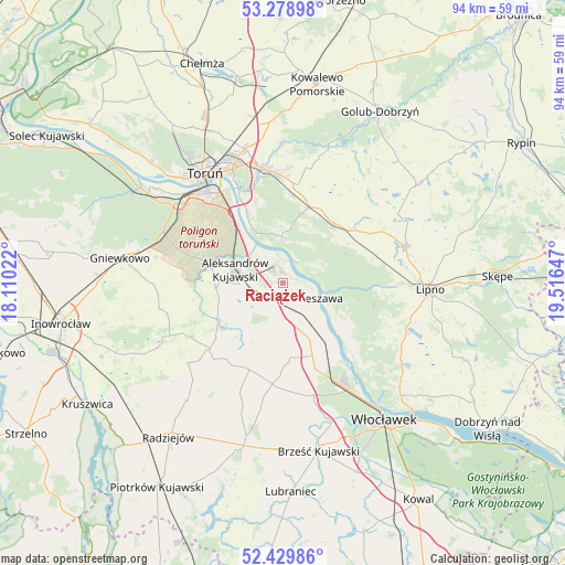
Raciążek GPS coordinates[2]
52° 51' 23.4" North, 18° 48' 48.024" East
| Map corner | latitude | longitude |
|---|---|---|
| Upper-left | 53.27898°, | 18.11022° |
| Center: | 52.8565°, | 18.81334° |
| Lower-right: | 52.42986°, | 19.51647° |
| Map W x H: | 94.4×94.4 km | = 58.7×58.7mi |
| max Lat: | 54.83135° ⇑18.4% North |
| Raciążek: | 52.8565° |
| min Lat: | ⇓81.6% South 49.21328° |
| min Long | Raciążek | max Long |
| 14.20249° | 18.81334° | 24.03723° |
| W 36.9%⇐ | ⇒63.1% E |
Elevation
Elevation of Raciążek is 83 m = 272 ft, and this is 108.4 m = 356 ft below average elevation for this country.
| Max E: |
974 m = 3196 ft | 87.5% |
| Avg. | 191.4 m = 628 ft | |
| Raciążek | 83 m = 272 ft | |
Min E: |
-3 m = -10 ft | 12.5% |
See also: Poland elevation on elevation.city.
Geographical zone
Raciążek is located in North temperate zone (between Tropic of Cancer and the Arctic Circle). Distance of this North polar circle is 1524.1 km =947 mi to North.| Distance of | km | miles | from Raciążek |
|---|---|---|---|
| North Pole | 4130 | 2566.3 | to North |
| Arctic Circle | 1524.1 | 947 | to North |
| Tropic Cancer | 3271.2 | 2032.6 | to South |
| Equator | 5877.1 | 3651.9 | to South |


Nearby cities:
15 places around Raciążek: (largest is in red/bold)
• Aleksandrów Kujawski
8.4 km =5.2 mi,  285°
285°
• Bobrowniki
13 km =8.1 mi,  130°
130°
• Bądkowo
16.9 km =10.5 mi,  185°
185°
• Ciechocinek
2.8 km =1.7 mi,  333°
333°
• Czernikowo
13.1 km =8.1 mi,  39°
39°
• Dąbrowa Biskupia
20.1 km =12.5 mi,  244°
244°
• Koneck
10.3 km =6.4 mi,  217°
217°
• Lubanie
14.1 km =8.8 mi,  149°
149°
• Lubicz Dolny
20 km =12.4 mi,  346°
346°
• Lubicz Górny
19.2 km =11.9 mi, 351°
• Nieszawa
6.3 km =3.9 mi,  112°
112°
• Obrowo
13.5 km =8.4 mi,  18°
18°
• Osiek
7.8 km =4.8 mi,  357°
357°
• Waganiec
7.4 km =4.6 mi, 145°
• Zakrzewo
16.3 km =10.1 mi,  228°
228°
Sources, notices
• [Note1] Compared only with cities in Poland existing in our database
• [Src1] Map data: © OpenStreetMap contributors (CC-BY-SA)
• [Src2] Other city data from geonames.org with taken over terms of usage.
• [Src3] Geographical zone / Annual Mean Temperature by Robert A. Rohde @ Wikipedia
