Obrowo geodata
Obrowo (Kujawsko-Pomorskie) is a seat of a third-order administrative division; located in Poland in Europe/Warsaw (GMT+2) time zone. With population of 1,410 people, there are 1941 cities with bigger population in this country. Compared to other cities in Poland, 83.2% of cities are located further ↓South; 62.3% of cities are located further →East and 84.6% of cities have higher elevation than Obrowo. Note1


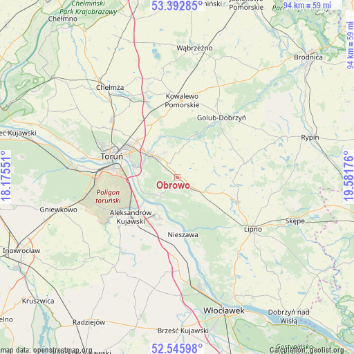
Obrowo GPS coordinates[2]
52° 58' 17.364" North, 18° 52' 43.068" East
| Map corner | latitude | longitude |
|---|---|---|
| Upper-left | 53.39285°, | 18.17551° |
| Center: | 52.97149°, | 18.87863° |
| Lower-right: | 52.54598°, | 19.58176° |
| Map W x H: | 94.2×94.2 km | = 58.5×58.5mi |
| max Lat: | 54.83135° ⇑16.8% North |
| Obrowo: | 52.97149° |
| min Lat: | ⇓83.2% South 49.21328° |
| min Long | Obrowo | max Long |
| 14.20249° | 18.87863° | 24.03723° |
| W 37.7%⇐ | ⇒62.3% E |
Elevation
Elevation of Obrowo is 90 m = 295 ft, and this is 101.4 m = 333 ft below average elevation for this country.
| Max E: |
974 m = 3196 ft | 84.6% |
| Avg. | 191.4 m = 628 ft | |
| Obrowo | 90 m = 295 ft | |
Min E: |
-3 m = -10 ft | 15.4% |
See also: Poland elevation on elevation.city.
Geographical zone
Obrowo is located in North temperate zone (between Tropic of Cancer and the Arctic Circle). Distance of this North polar circle is 1511.3 km =939.1 mi to North.| Distance of | km | miles | from Obrowo |
|---|---|---|---|
| North Pole | 4117.2 | 2558.3 | to North |
| Arctic Circle | 1511.3 | 939.1 | to North |
| Tropic Cancer | 3284 | 2040.6 | to South |
| Equator | 5889.9 | 3659.8 | to South |


Nearby cities:
15 places around Obrowo: (largest is in red/bold)
• Aleksandrów Kujawski
16.3 km =10.1 mi,  229°
229°
• Ciechocin
9.9 km =6.2 mi,  18°
18°
• Ciechocinek
11.7 km =7.3 mi,  208°
208°
• Czernikowo
4.8 km =3 mi,  124°
124°
• Golub-Dobrzyń
19.4 km =12.1 mi,  37°
37°
• Kikół
17.6 km =10.9 mi,  112°
112°
• Lubicz Dolny
11.1 km =6.9 mi,  306°
306°
• Lubicz Górny
9.5 km =5.9 mi, 310°
• Lubin
15.9 km =9.9 mi,  104°
104°
• Nieszawa
15.3 km =9.5 mi,  174°
174°
• Osiek
6.9 km =4.3 mi,  223°
223°
• Raciążek
13.5 km =8.4 mi,  198°
198°
• Waganiec
18.9 km =11.7 mi,  180°
180°
• Wielgie
15.3 km =9.5 mi,  77°
77°
• Zbójno
19.1 km =11.9 mi, 77°
Sources, notices
• [Note1] Compared only with cities in Poland existing in our database
• [Src1] Map data: © OpenStreetMap contributors (CC-BY-SA)
• [Src2] Other city data from geonames.org with taken over terms of usage.
• [Src3] Geographical zone / Annual Mean Temperature by Robert A. Rohde @ Wikipedia
