Bobrowniki geodata
Bobrowniki (Kujawsko-Pomorskie) is a seat of a third-order administrative division; located in Poland in Europe/Warsaw (GMT+2) time zone. With population of 980 people, there are 2532 cities with bigger population in this country. Compared to other cities in Poland, 80.6% of cities are located further ↓South; 60.7% of cities are located further →East and 93.1% of cities have higher elevation than Bobrowniki. Note1
Administrative division(s):
- Level 1: Kujawsko-Pomorskie
- Level 2: Powiat lipnowski
- Level 3: Bobrowniki


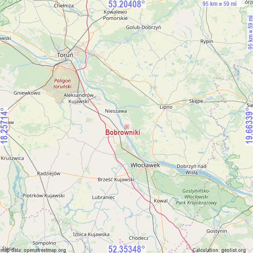
Bobrowniki GPS coordinates[2]
52° 46' 51.096" North, 18° 57' 36.936" East
| Map corner | latitude | longitude |
|---|---|---|
| Upper-left | 53.20408°, | 18.25714° |
| Center: | 52.78086°, | 18.96026° |
| Lower-right: | 52.35348°, | 19.66339° |
| Map W x H: | 94.6×94.6 km | = 58.8×58.8mi |
| max Lat: | 54.83135° ⇑19.4% North |
| Bobrowniki: | 52.78086° |
| min Lat: | ⇓80.6% South 49.21328° |
| min Long | Bobrowniki | max Long |
| 14.20249° | 18.96026° | 24.03723° |
| W 39.3%⇐ | ⇒60.7% E |
Elevation
Elevation of Bobrowniki is 59 m = 194 ft, and this is 132.4 m = 434 ft below average elevation for this country.
| Max E: |
974 m = 3196 ft | 93.1% |
| Avg. | 191.4 m = 628 ft | |
| Bobrowniki | 59 m = 194 ft | |
Min E: |
-3 m = -10 ft | 6.9% |
See also: Poland elevation on elevation.city.
Geographical zone
Bobrowniki is located in North temperate zone (between Tropic of Cancer and the Arctic Circle). Distance of this North polar circle is 1532.5 km =952.3 mi to North.| Distance of | km | miles | from Bobrowniki |
|---|---|---|---|
| North Pole | 4138.4 | 2571.5 | to North |
| Arctic Circle | 1532.5 | 952.3 | to North |
| Tropic Cancer | 3262.8 | 2027.4 | to South |
| Equator | 5868.7 | 3646.6 | to South |


Nearby cities:
15 places around Bobrowniki: (largest is in red/bold)
• Brześć Kujawski
19.9 km =12.4 mi,  191°
191°
• Bądkowo
14.4 km =8.9 mi,  234°
234°
• Ciechocinek
15.6 km =9.7 mi,  314°
314°
• Czernikowo
18.5 km =11.5 mi,  355°
355°
• Fabianki
12.2 km =7.6 mi,  124°
124°
• Kikół
17.9 km =11.1 mi,  36°
36°
• Koneck
16.2 km =10.1 mi,  270°
270°
• Lipno
16.3 km =10.1 mi,  64°
64°
• Lubanie
4.7 km =2.9 mi,  216°
216°
• Nieszawa
7.2 km =4.5 mi,  325°
325°
• Osiek
19.1 km =11.9 mi, 327°
• Raciążek
13 km =8.1 mi, 310°
• Waganiec
6.1 km =3.8 mi,  291°
291°
• Witkowo
14.9 km =9.3 mi,  98°
98°
• Włocławek
16.4 km =10.2 mi,  153°
153°
Sources, notices
• [Note1] Compared only with cities in Poland existing in our database
• [Src1] Map data: © OpenStreetMap contributors (CC-BY-SA)
• [Src2] Other city data from geonames.org with taken over terms of usage.
• [Src3] Geographical zone / Annual Mean Temperature by Robert A. Rohde @ Wikipedia
