Niechorze geodata
Niechorze (West Pomerania) is a populated place; located in Poland in Europe/Warsaw (GMT+2) time zone. With population of 927 people, there are 2627 cities with bigger population in this country. Compared to other cities in Poland, 95.2% of cities are located further ↓South; 97.5% of cities are located further →East and 99.1% of cities have higher elevation than Niechorze. Note1


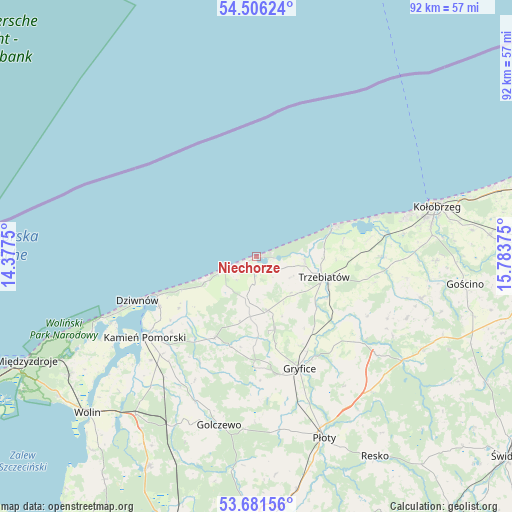
Niechorze GPS coordinates[2]
54° 5' 45.42" North, 15° 4' 50.232" East
| Map corner | latitude | longitude |
|---|---|---|
| Upper-left | 54.50624°, | 14.3775° |
| Center: | 54.09595°, | 15.08062° |
| Lower-right: | 53.68156°, | 15.78375° |
| Map W x H: | 91.7×91.7 km | = 57×57mi |
| max Lat: | 54.83135° ⇑4.8% North |
| Niechorze: | 54.09595° |
| min Lat: | ⇓95.2% South 49.21328° |
| min Long | Niechorze | max Long |
| 14.20249° | 15.08062° | 24.03723° |
| W 2.5%⇐ | ⇒97.5% E |
Elevation
Elevation of Niechorze is 4 m = 13 ft, and this is 187.4 m = 615 ft below average elevation for this country.
| Max E: |
974 m = 3196 ft | 99.1% |
| Avg. | 191.4 m = 628 ft | |
| Niechorze | 4 m = 13 ft | |
Min E: |
-3 m = -10 ft | 0.9% |
See also: Poland elevation on elevation.city.
Geographical zone
Niechorze is located in North temperate zone (between Tropic of Cancer and the Arctic Circle). Distance of this North polar circle is 1386.3 km =861.4 mi to North.| Distance of | km | miles | from Niechorze |
|---|---|---|---|
| North Pole | 3992.2 | 2480.6 | to North |
| Arctic Circle | 1386.3 | 861.4 | to North |
| Tropic Cancer | 3409 | 2118.3 | to South |
| Equator | 6014.9 | 3737.5 | to South |


Nearby cities:
15 places around Niechorze: (largest is in red/bold)
• Brojce
23.9 km =14.9 mi,  130°
130°
• Cerkwica
10 km =6.2 mi,  169°
169°
• Drzonowo
23.2 km =14.4 mi,  89°
89°
• Dziwnów
21.8 km =13.5 mi,  249°
249°
• Dźwirzyno
22.7 km =14.1 mi,  71°
71°
• Gostyń
11.5 km =7.1 mi,  229°
229°
• Gryfice
21.4 km =13.3 mi,  158°
158°
• Kamień Pomorski
24.6 km =15.3 mi, 234°
• Karnice
7.5 km =4.7 mi,  192°
192°
• Międzywodzie
27 km =16.8 mi, 247°
• Mrzeżyno
14.7 km =9.1 mi, 68°
• Pobierowo
10.4 km =6.5 mi, 248°
• Rewal
4.6 km =2.9 mi, 249°
• Trzebiatów
12.6 km =7.8 mi,  107°
107°
• Świerzno
16.4 km =10.2 mi,  207°
207°
Sources, notices
• [Note1] Compared only with cities in Poland existing in our database
• [Src1] Map data: © OpenStreetMap contributors (CC-BY-SA)
• [Src2] Other city data from geonames.org with taken over terms of usage.
• [Src3] Geographical zone / Annual Mean Temperature by Robert A. Rohde @ Wikipedia
