Brojce geodata
Brojce (West Pomerania) is a seat of a third-order administrative division; located in Poland in Europe/Warsaw (GMT+2) time zone. With population of 1,248 people, there are 2128 cities with bigger population in this country. Compared to other cities in Poland, 93.8% of cities are located further ↓South; 96.2% of cities are located further →East and 95.9% of cities have higher elevation than Brojce. Note1


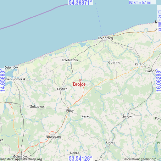
Brojce GPS coordinates[2]
53° 57' 25.38" North, 15° 21' 35.1" East
| Map corner | latitude | longitude |
|---|---|---|
| Upper-left | 54.36871°, | 14.65663° |
| Center: | 53.95705°, | 15.35975° |
| Lower-right: | 53.54128°, | 16.06288° |
| Map W x H: | 92×92 km | = 57.2×57.2mi |
| max Lat: | 54.83135° ⇑6.2% North |
| Brojce: | 53.95705° |
| min Lat: | ⇓93.8% South 49.21328° |
| min Long | Brojce | max Long |
| 14.20249° | 15.35975° | 24.03723° |
| W 3.8%⇐ | ⇒96.2% E |
Elevation
Elevation of Brojce is 33 m = 108 ft, and this is 158.4 m = 520 ft below average elevation for this country.
| Max E: |
974 m = 3196 ft | 95.9% |
| Avg. | 191.4 m = 628 ft | |
| Brojce | 33 m = 108 ft | |
Min E: |
-3 m = -10 ft | 4.1% |
See also: Poland elevation on elevation.city.
Geographical zone
Brojce is located in North temperate zone (between Tropic of Cancer and the Arctic Circle). Distance of this North polar circle is 1401.7 km =871 mi to North.| Distance of | km | miles | from Brojce |
|---|---|---|---|
| North Pole | 4007.6 | 2490.2 | to North |
| Arctic Circle | 1401.7 | 871 | to North |
| Tropic Cancer | 3393.5 | 2108.6 | to South |
| Equator | 5999.5 | 3727.9 | to South |


Nearby cities:
15 places around Brojce: (largest is in red/bold)
• Cerkwica
17.3 km =10.7 mi,  288°
288°
• Drzonowo
16.3 km =10.1 mi,  17°
17°
• Dźwirzyno
22.7 km =14.1 mi,  8°
8°
• Gościno
21.8 km =13.5 mi,  61°
61°
• Gryfice
11.4 km =7.1 mi,  246°
246°
• Grzybowo
23.9 km =14.9 mi, 20°
• Karnice
21.5 km =13.4 mi, 292°
• Mrzeżyno
21.2 km =13.2 mi,  347°
347°
• Mysłowice
19.3 km =12 mi,  111°
111°
• Płoty
18.3 km =11.4 mi,  199°
199°
• Resko
20.7 km =12.9 mi,  171°
171°
• Rymań
11.1 km =6.9 mi,  97°
97°
• Siemyśl
13.8 km =8.6 mi, 55°
• Sławoborze
23.9 km =14.9 mi, 108°
• Trzebiatów
13.2 km =8.2 mi,  331°
331°
Sources, notices
• [Note1] Compared only with cities in Poland existing in our database
• [Src1] Map data: © OpenStreetMap contributors (CC-BY-SA)
• [Src2] Other city data from geonames.org with taken over terms of usage.
• [Src3] Geographical zone / Annual Mean Temperature by Robert A. Rohde @ Wikipedia
