Cerkwica geodata
Cerkwica (West Pomerania) is a populated place; located in Poland in Europe/Warsaw (GMT+2) time zone. With population of 1,261 people, there are 2116 cities with bigger population in this country. Compared to other cities in Poland, 94.3% of cities are located further ↓South; 97.3% of cities are located further →East and 97.2% of cities have higher elevation than Cerkwica. Note1


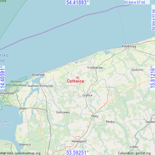
Cerkwica GPS coordinates[2]
54° 0' 27.972" North, 15° 6' 32.508" East
| Map corner | latitude | longitude |
|---|---|---|
| Upper-left | 54.41893°, | 14.40591° |
| Center: | 54.00777°, | 15.10903° |
| Lower-right: | 53.59251°, | 15.81216° |
| Map W x H: | 91.9×91.9 km | = 57.1×57.1mi |
| max Lat: | 54.83135° ⇑5.7% North |
| Cerkwica: | 54.00777° |
| min Lat: | ⇓94.3% South 49.21328° |
| min Long | Cerkwica | max Long |
| 14.20249° | 15.10903° | 24.03723° |
| W 2.7%⇐ | ⇒97.3% E |
Elevation
Elevation of Cerkwica is 20 m = 66 ft, and this is 171.4 m = 562 ft below average elevation for this country.
| Max E: |
974 m = 3196 ft | 97.2% |
| Avg. | 191.4 m = 628 ft | |
| Cerkwica | 20 m = 66 ft | |
Min E: |
-3 m = -10 ft | 2.8% |
See also: Poland elevation on elevation.city.
Geographical zone
Cerkwica is located in North temperate zone (between Tropic of Cancer and the Arctic Circle). Distance of this North polar circle is 1396.1 km =867.5 mi to North.| Distance of | km | miles | from Cerkwica |
|---|---|---|---|
| North Pole | 4002 | 2486.7 | to North |
| Arctic Circle | 1396.1 | 867.5 | to North |
| Tropic Cancer | 3399.2 | 2112.2 | to South |
| Equator | 6005.1 | 3731.4 | to South |


Nearby cities:
15 places around Cerkwica: (largest is in red/bold)
• Brojce
17.3 km =10.7 mi,  108°
108°
• Drzonowo
23.5 km =14.6 mi,  65°
65°
• Dziwnów
22.5 km =14 mi,  275°
275°
• Golczewo
22.1 km =13.7 mi,  202°
202°
• Gostyń
10.8 km =6.7 mi, 282°
• Gryfice
11.8 km =7.3 mi,  149°
149°
• Kamień Pomorski
22.4 km =13.9 mi,  258°
258°
• Karnice
4.3 km =2.7 mi,  304°
304°
• Mrzeżyno
19.2 km =11.9 mi,  38°
38°
• Niechorze
10 km =6.2 mi,  349°
349°
• Pobierowo
12.9 km =8 mi, 297°
• Płoty
25.1 km =15.6 mi,  155°
155°
• Rewal
10.2 km =6.3 mi,  322°
322°
• Trzebiatów
11.8 km =7.3 mi,  59°
59°
• Świerzno
10.5 km =6.5 mi,  243°
243°
Sources, notices
• [Note1] Compared only with cities in Poland existing in our database
• [Src1] Map data: © OpenStreetMap contributors (CC-BY-SA)
• [Src2] Other city data from geonames.org with taken over terms of usage.
• [Src3] Geographical zone / Annual Mean Temperature by Robert A. Rohde @ Wikipedia
