Świerzno geodata
Świerzno (West Pomerania) is a seat of a third-order administrative division; located in Poland in Europe/Warsaw (GMT+2) time zone. With population of 670 people, there are 3129 cities with bigger population in this country. Compared to other cities in Poland, 93.8% of cities are located further ↓South; 98.2% of cities are located further →East and 97.9% of cities have higher elevation than Świerzno. Note1


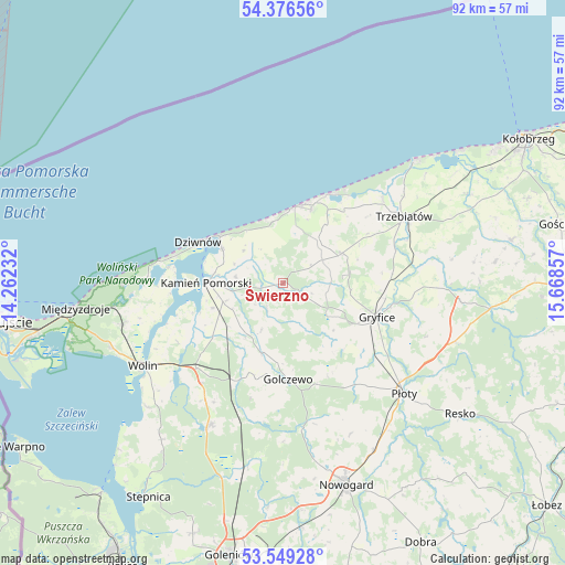
Świerzno GPS coordinates[2]
53° 57' 53.892" North, 14° 57' 55.584" East
| Map corner | latitude | longitude |
|---|---|---|
| Upper-left | 54.37656°, | 14.26232° |
| Center: | 53.96497°, | 14.96544° |
| Lower-right: | 53.54928°, | 15.66857° |
| Map W x H: | 92×92 km | = 57.2×57.2mi |
| max Lat: | 54.83135° ⇑6.2% North |
| Świerzno: | 53.96497° |
| min Lat: | ⇓93.8% South 49.21328° |
| min Long | Świerzno | max Long |
| 14.20249° | 14.96544° | 24.03723° |
| W 1.8%⇐ | ⇒98.2% E |
Elevation
Elevation of Świerzno is 16 m = 52 ft, and this is 175.4 m = 575 ft below average elevation for this country.
| Max E: |
974 m = 3196 ft | 97.9% |
| Avg. | 191.4 m = 628 ft | |
| Świerzno | 16 m = 52 ft | |
Min E: |
-3 m = -10 ft | 2.1% |
See also: Poland elevation on elevation.city.
Geographical zone
Świerzno is located in North temperate zone (between Tropic of Cancer and the Arctic Circle). Distance of this North polar circle is 1400.8 km =870.4 mi to North.| Distance of | km | miles | from Świerzno |
|---|---|---|---|
| North Pole | 4006.7 | 2489.6 | to North |
| Arctic Circle | 1400.8 | 870.4 | to North |
| Tropic Cancer | 3394.4 | 2109.2 | to South |
| Equator | 6000.3 | 3728.4 | to South |


Nearby cities:
15 places around Świerzno: (largest is in red/bold)
• Brojce
25.8 km =16 mi,  91°
91°
• Cerkwica
10.5 km =6.5 mi,  63°
63°
• Czarnogłowy
22.2 km =13.8 mi,  189°
189°
• Dziwnów
14.8 km =9.2 mi,  298°
298°
• Golczewo
15.7 km =9.8 mi,  176°
176°
• Gostyń
7.1 km =4.4 mi,  350°
350°
• Gryfice
16.3 km =10.1 mi,  109°
109°
• Kamień Pomorski
12.6 km =7.8 mi,  271°
271°
• Karnice
9.3 km =5.8 mi,  38°
38°
• Międzywodzie
18.1 km =11.2 mi,  284°
284°
• Niechorze
16.4 km =10.2 mi,  27°
27°
• Pobierowo
10.9 km =6.8 mi, 348°
• Przybiernów
25.9 km =16.1 mi,  207°
207°
• Rewal
13.3 km =8.3 mi,  13°
13°
• Trzebiatów
22.3 km =13.9 mi, 61°
Sources, notices
• [Note1] Compared only with cities in Poland existing in our database
• [Src1] Map data: © OpenStreetMap contributors (CC-BY-SA)
• [Src2] Other city data from geonames.org with taken over terms of usage.
• [Src3] Geographical zone / Annual Mean Temperature by Robert A. Rohde @ Wikipedia
