Lgota geodata
Lgota (Lesser Poland) is a populated place; located in Poland in Europe/Warsaw (GMT+1) time zone. With population of 930 people, there are 2620 cities with bigger population in this country. Compared to other cities in Poland, 74.2% of cities are located further ↑North; 50.2% of cities are located further →East and 96.6% of cities have lower elevation than Lgota. Note1


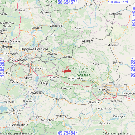
Lgota GPS coordinates[2]
50° 12' 24.048" North, 19° 33' 18.54" East
| Map corner | latitude | longitude |
|---|---|---|
| Upper-left | 50.65457°, | 18.85203° |
| Center: | 50.20668°, | 19.55515° |
| Lower-right: | 49.75454°, | 20.25828° |
| Map W x H: | 100.1×100.1 km | = 62.2×62.2mi |
| max Lat: | 54.83135° ⇑74.2% North |
| Lgota: | 50.20668° |
| min Lat: | ⇓25.8% South 49.21328° |
| min Long | Lgota | max Long |
| 14.20249° | 19.55515° | 24.03723° |
| W 49.8%⇐ | ⇒50.2% E |
Elevation
Elevation of Lgota is 461 m = 1512 ft, and this is 269.6 m = 885 ft above average elevation for this country.
| Max E: |
974 m = 3196 ft | 3.4% |
| Lgota | 461 m 1512 ft | |
| Avg. | 191.4 m = 628 ft | |
Min E: |
-3 m = -10 ft | 96.6% |
See also: Poland elevation on elevation.city.
Geographical zone
Lgota is located in North temperate zone (between Tropic of Cancer and the Arctic Circle). Distance of this North polar circle is 1818.7 km =1130.1 mi to North.| Distance of | km | miles | from Lgota |
|---|---|---|---|
| North Pole | 4424.6 | 2749.3 | to North |
| Arctic Circle | 1818.7 | 1130.1 | to North |
| Tropic Cancer | 2976.5 | 1849.5 | to South |
| Equator | 5582.5 | 3468.8 | to South |


Nearby cities:
15 places around Lgota: (largest is in red/bold)
• Filipowice
5.7 km =3.5 mi,  172°
172°
• Gorenice
4.6 km =2.9 mi,  88°
88°
• Miękinia
6.8 km =4.2 mi,  146°
146°
• Myślachowice
5.8 km =3.6 mi,  245°
245°
• Niesułowice
1.8 km =1.1 mi,  4°
4°
• Nowa Góra
4.5 km =2.8 mi, 145°
• Olkusz
8.3 km =5.2 mi, 4°
• Osiek
5.2 km =3.2 mi,  38°
38°
• Ostrężnica
1.9 km =1.2 mi,  144°
144°
• Psary
4.2 km =2.6 mi,  205°
205°
• Płoki
2.9 km =1.8 mi,  267°
267°
• Racławice
8.8 km =5.5 mi,  99°
99°
• Sieniczno
7.9 km =4.9 mi,  30°
30°
• Trzebinia
8 km =5 mi,  229°
229°
• Wola Filipowska
8.2 km =5.1 mi, 167°
Sources, notices
• [Note1] Compared only with cities in Poland existing in our database
• [Src1] Map data: © OpenStreetMap contributors (CC-BY-SA)
• [Src2] Other city data from geonames.org with taken over terms of usage.
• [Src3] Geographical zone / Annual Mean Temperature by Robert A. Rohde @ Wikipedia
