Racławice geodata
Racławice (Lesser Poland) is a populated place; located in Poland in Europe/Warsaw (GMT+2) time zone. With population of 1,540 people, there are 1813 cities with bigger population in this country. Compared to other cities in Poland, 74.7% of cities are located further ↑North; 52.2% of cities are located further ←West and 92.4% of cities have lower elevation than Racławice. Note1
Administrative division(s):
- Level 1: Lesser Poland
- Level 2: Powiat krakowski
- Level 3: Jerzmanowice-Przeginia


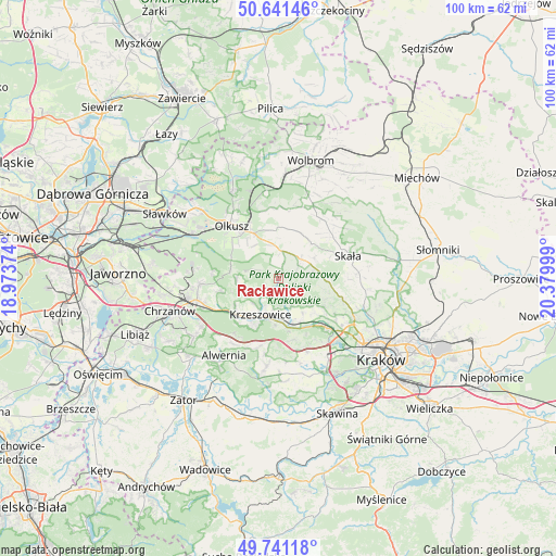
Racławice GPS coordinates[2]
50° 11' 36.384" North, 19° 40' 36.696" East
| Map corner | latitude | longitude |
|---|---|---|
| Upper-left | 50.64146°, | 18.97374° |
| Center: | 50.19344°, | 19.67686° |
| Lower-right: | 49.74118°, | 20.37999° |
| Map W x H: | 100.1×100.1 km | = 62.2×62.2mi |
| max Lat: | 54.83135° ⇑74.7% North |
| Racławice: | 50.19344° |
| min Lat: | ⇓25.3% South 49.21328° |
| min Long | Racławice | max Long |
| 14.20249° | 19.67686° | 24.03723° |
| W 52.2%⇐ | ⇒47.8% E |
Elevation
Elevation of Racławice is 361 m = 1184 ft, and this is 169.6 m = 556 ft above average elevation for this country.
| Max E: |
974 m = 3196 ft | 7.6% |
| Racławice | 361 m 1184 ft | |
| Avg. | 191.4 m = 628 ft | |
Min E: |
-3 m = -10 ft | 92.4% |
See also: Poland elevation on elevation.city.
Geographical zone
Racławice is located in North temperate zone (between Tropic of Cancer and the Arctic Circle). Distance of this North polar circle is 1820.2 km =1131 mi to North.| Distance of | km | miles | from Racławice |
|---|---|---|---|
| North Pole | 4426.1 | 2750.3 | to North |
| Arctic Circle | 1820.2 | 1131 | to North |
| Tropic Cancer | 2975.1 | 1848.6 | to South |
| Equator | 5581 | 3467.9 | to South |


Nearby cities:
15 places around Racławice: (largest is in red/bold)
• Brzezinka
7.7 km =4.8 mi,  145°
145°
• Bębło
8 km =5 mi,  100°
100°
• Gorenice
4.3 km =2.7 mi,  291°
291°
• Jerzmanowice
5.4 km =3.4 mi,  66°
66°
• Karniowice
8.7 km =5.4 mi,  123°
123°
• Kobylany
7.7 km =4.8 mi,  128°
128°
• Krzeszowice
6.5 km =4 mi,  209°
209°
• Miękinia
6.4 km =4 mi,  229°
229°
• Nowa Góra
6.5 km =4 mi,  249°
249°
• Osiek
7.8 km =4.8 mi,  315°
315°
• Ostrężnica
7.6 km =4.7 mi,  269°
269°
• Przeginia
5.1 km =3.2 mi,  9°
9°
• Rudawa
8.4 km =5.2 mi,  162°
162°
• Sąspów
7.7 km =4.8 mi,  59°
59°
• Więckowice
8.8 km =5.5 mi,  135°
135°
Sources, notices
• [Note1] Compared only with cities in Poland existing in our database
• [Src1] Map data: © OpenStreetMap contributors (CC-BY-SA)
• [Src2] Other city data from geonames.org with taken over terms of usage.
• [Src3] Geographical zone / Annual Mean Temperature by Robert A. Rohde @ Wikipedia
