Trzebinia geodata
Trzebinia (Lesser Poland) is a seat of a third-order administrative division; located in Poland in Europe/Warsaw (GMT+2) time zone. With population of 18,828 people, there are 257 cities with bigger population in this country. Compared to other cities in Poland, 75.7% of cities are located further ↑North; 51.6% of cities are located further →East and 88.6% of cities have lower elevation than Trzebinia. Note1


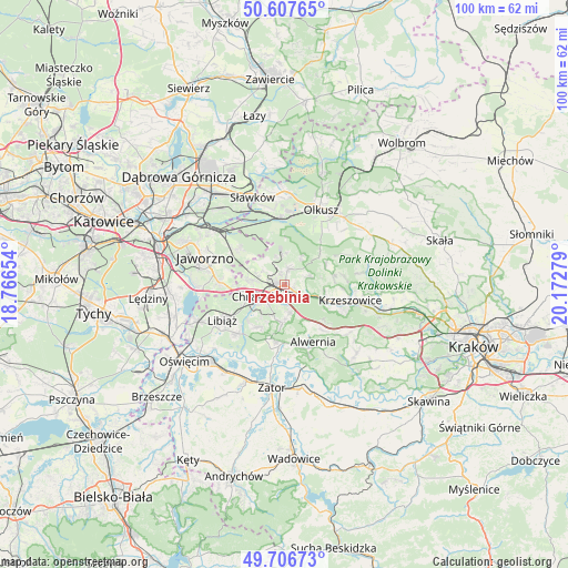
Trzebinia GPS coordinates[2]
50° 9' 33.516" North, 19° 28' 10.776" East
| Map corner | latitude | longitude |
|---|---|---|
| Upper-left | 50.60765°, | 18.76654° |
| Center: | 50.15931°, | 19.46966° |
| Lower-right: | 49.70673°, | 20.17279° |
| Map W x H: | 100.2×100.2 km | = 62.3×62.3mi |
| max Lat: | 54.83135° ⇑75.7% North |
| Trzebinia: | 50.15931° |
| min Lat: | ⇓24.3% South 49.21328° |
| min Long | Trzebinia | max Long |
| 14.20249° | 19.46966° | 24.03723° |
| W 48.4%⇐ | ⇒51.6% E |
Elevation
Elevation of Trzebinia is 314 m = 1030 ft, and this is 122.6 m = 402 ft above average elevation for this country.
| Max E: |
974 m = 3196 ft | 11.4% |
| Trzebinia | 314 m 1030 ft | |
| Avg. | 191.4 m = 628 ft | |
Min E: |
-3 m = -10 ft | 88.6% |
See also: Poland elevation on elevation.city.
Geographical zone
Trzebinia is located in North temperate zone (between Tropic of Cancer and the Arctic Circle). Distance of this North polar circle is 1824 km =1133.4 mi to North.| Distance of | km | miles | from Trzebinia |
|---|---|---|---|
| North Pole | 4429.9 | 2752.6 | to North |
| Arctic Circle | 1824 | 1133.4 | to North |
| Tropic Cancer | 2971.3 | 1846.3 | to South |
| Equator | 5577.2 | 3465.5 | to South |


Nearby cities:
15 places around Trzebinia: (largest is in red/bold)
• Balin
6.2 km =3.9 mi,  278°
278°
• Bolęcin
4.7 km =2.9 mi,  170°
170°
• Chrzanów
5.5 km =3.4 mi,  241°
241°
• Filipowice
6.9 km =4.3 mi,  93°
93°
• Lgota
8 km =5 mi,  49°
49°
• Luszowice
4.9 km =3 mi,  289°
289°
• Myślachowice
3 km =1.9 mi,  15°
15°
• Ostrężnica
8.1 km =5 mi,  62°
62°
• Piła Kościelecka
3.1 km =1.9 mi,  189°
189°
• Pogorzyce
7.2 km =4.5 mi,  207°
207°
• Psary
4.5 km =2.8 mi,  71°
71°
• Płaza
6.6 km =4.1 mi,  183°
183°
• Płoki
6.1 km =3.8 mi,  32°
32°
• Wola Filipowska
8.3 km =5.2 mi,  109°
109°
• Zagórze
8.6 km =5.3 mi, 213°
Sources, notices
• [Note1] Compared only with cities in Poland existing in our database
• [Src1] Map data: © OpenStreetMap contributors (CC-BY-SA)
• [Src2] Other city data from geonames.org with taken over terms of usage.
• [Src3] Geographical zone / Annual Mean Temperature by Robert A. Rohde @ Wikipedia
